interkriti®
YOUR GATEWAY TO CRETE
HOME
CRETE FACTS
NAVIGATE
EXPLORE

Agia Galini
Triopetra
Kissamos
Chryssi Isl.
Agia Marina
Balos
Gavdos isl.
Georgioupolis
SAMARIA
IDA Mtn
Palaiochora
Agia Roumeli
Sfakaki
Bali
Kalamaki
Matala
Lassithi
Plateau Lendas
Tsoutsouros
Vianos
Myrtos
Sfakia
Plakias
Ierapetra
Makrygialos
ZAKROS
Vai
Sitia
Agios Nikolaos
Elounda
MALIA
Hersonissos
Gouves
Chania
Rethymnon
Heraklion
GORTYN
FESTOS
KNOSSOS
|
|
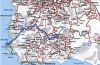
Crete
List Grid Map
Found
36
- Showing :
1 - 20
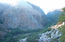 Kissamos at 0km (N) A small village 21km away from Kastelli Kissamou,at 340 m. a.s.l with 57 permanent residents. The village is mentioned by Fr. Barozzi since 1577. A little before the village of Sassalos, starts the gorge of Salasse, a small one which leads to Tyflos river, and is worthy to walk.
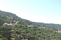 Kissamos, Hania at 3.4km (NW) Α principal village located at 280m a.sl., on the main road to the southern coast, 47km from Hania and 22km from Kastelli with 370 inhabitants. There are a post Office and police station, workshops, olive press, wheat mill etc. The village lies at the entrance of the gorge of Topolia and 27 km away is the monastery of Chrissoskalitissa. The gorge is lush with plane-trees, wild olive trees, flowers, and bushes. Its walls are 300m high, and the width in some cases is 5m only. Through the gorge flows the river Tiflos. A little after the village, there is a well maintained footpath on the mountain side which reaches the Agia Sophia Cave at 285m a.s.l. The cave is of great scientific interest, has a diameter of 70m and it is 20m high. There are marvelous stalagmites and stalactites of various shapes. At the left end there is a small church with an icon that, as tradition says, came from Constantinople, and has been wedged in a rock. In the cave were discovered many finds from neolithic era. Two patron feasts are taking place there each year: One on Tuesday after Easter and a second on December 24, when the birth of Jesus is represented. 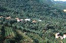 Kissamos, Hania at 5.7km (W) Vlatos is located at 380m a.s.l., 54 km away from Hania and 18 km from Kastelli Kissamou. It is built in a tree covered valley, with olive trees, chestnut trees and wild vegetation. There are some very nice trekking paths around and in the forest of "Peace" which has been characterized as a natural park. The "Park of Peace" was founded in 1970 by the Cultural Association of Vlatos with the cooparation of Goethe Institute and the support of the Bavarian Department of Forests. It is an experimental park with 150 species of plants, covers an area of 1,000,000 sq.m. and is part of an extended area of 20 sq.km. which have been reforested. 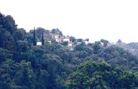 Kissamos at 6.3km (W) Sirikari (GR Σηρικάρι) is a small village located 52 km away from Hania and 14 km from Kastelli at 500m a.s.l. The name Sirikari probably comes from the profession of the first settler, who has to be a silk weaver (Sirikaris). A short ravine starts from Sirikari and ends close to Polyrinia. There is also a chestnut tree forest, the cave of the Holy Mother (Panagias), the byzantine church of Agii Apostoli, with frescoes of 14th century a monument of great importance and two old factories. 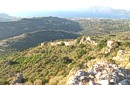 archaeological site in Kissamos at 7.7km (NW) Polyrinia (GR: Πολυρρήνια) was one of the most important cities-states of the Western Crete.It was built amphitheatrically on top of the hill (418 m altitude) with a commanding view of both the Cretan and the Libyan sea, located 49 km from Hania and 6 km from Kissamos . The history of Polyrinia starts in the Minoan period and continues to the present day.
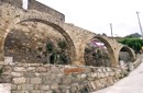 Kissamos at 7.8km (NW) The village of Polyrinia is built on the foot of the hill that ancient Polyrinia used to be. It is a small village located 6.5km away from Kastelli Kissamou, built at an altitude of 300 m. and has approximately 100 permanent residents. Its old name was Apano Paleokastro and was renamed to Polyrinia due to its proximity to the archaeological site. Important sights are: the aqueduct of Andrianos, the temple of the Assumption of the Holly-Mother and an old olive mill.
 by Richard Ellis at 8.9km (S) 2nd September - I was up and away from Kandanos by 0650 with the intention of meeting Susa at Elos, spending the night there and dropping down to the west coast next morning. However, it is good to be flexible. The verges of the road to Elos were full of "mellow fruitfulness" - I enjoyed handfuls of blackberries and a couple of the sweetest figs I have ever tasted. The sweet chestnuts were looking good for later, but as all over Crete the grapes had been badly spoiled by a very cold wet Spring. Distance: 32.3 km Time: 7 hrs. Mov av 5.3 km/hr Height: Sea level. 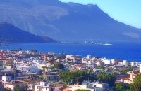 Kissamos, Hania at 11.2km (NW) The beautiful town of Kissamos is located 42 km west of Hania and it is the capital of the Kissamos county. Kissamos is surrounded by beautiful landscape and has about 3.000 inhabitants. Kissamos is not a crowdy tourist resort, its development is based mostly in the wine and oil produce, and the agricultural products. Kissamos is built along a wonderful sandy beach. It is located where the ancient city of Kissamos stood. With Kissamos as a starting point you can visit the archaeological sites of Falassarna and Polyrinia, the Gramvoussa isles (pirate isles), the beautiful Georges of Topolia, Sirikari, the lagoon of Balos, the medieval villages, etc.  Kissamos west coast at 12.3km (NW) Platanos (GR: Πλάτανος = plane-tree) is located 10 km from Kasteli Kissamos. It is a large village, the second largest in Kissamos area, after Kasteli. It has approximately 1000 inhabidants, which are occupied mainly in green house and olive cultivation and tourism. There is a doctor's office, gas stations, many shops, rooms for rent and taverns. At the village's old square stand a plane-tree with a fountain. 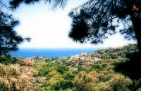 Kissamos west coast at 12.9km (W) The village of Sfinari is blessed with many water sources so it is overwhelmed with trees and flowers. Fresh fish is guaranteed as it abounds in the sea around the village, dolphins are often seen in the sea. To the rocks near the beautiful beach of Sfinari come the seals to give birth to their babes. The village offers many rooms for accommodation and there are taverns in the village and by the beach in the trees that cover the sea side.
Image Library
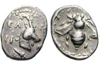 Selino, Hania at 15km (SE) Elyros ("Έλυρος" in Greek) is an ancient city, located in southwest Crete, in Kefala Hill, near the village Rodovani and is presently unexcavated. Elyros was flourishing at least as early as the Greek Classical Period, e.g. 500 to 350 BC. In the Classical Period Elyros was the most important ancient city in southwestern Crete, having about 16,000 inhabitants. It was an industrial and commercial city with large weapons production. Syia and Lissos were its harbours. Apollo, Phylakides and Philandros, sons of Apollo and nymph Akakallida, were worshiped there. In the third century BC Elyros was at war with Kydonia, an important center of Cretan power, located in the modern city of Chania. The citizens of Elyros sent to the Delphi Oracle, a bronze votive complex that represents a goat feeding the sons of Apollo when they were infants. It is also one of the thirty cities that signed the decree with Eumenes B’ in 183 BC.Elyros was also important during Roman times. A Roman statue, the Philosopher of Elyros was recovered here and is now in the Archaeological Museum of Chania. During Byzantine times, Elyros was the seat of an Archbishop and the remains of the bishopric church, a sixth century basilica, can still be seen in the centre of the old city. Robert Pashley was the first who identified the location of the city, near village Rodovani. Thenon studied more carefully the ruins of the city and discovered the inscription that says: “it seemed to the city of the Elyrians”. The output of its mint consists of silver drachms from the 3rd c. BC, which depict a wild goat and a bee; in addition to their function as religious symbols, these undoubtedly hint at the stock-raising activities in the region, particularly to this kind of wild goat, which can still be found in great numbers on the island. The bee also has reference to the abundant honey-production of Crete. 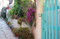 Kissamos at 15.2km (NW) The beautiful village of Kaliviani (GR: Καλυβιανή) is located in the beginning of the peninsula of Gramvoussa. The beauty of the village can be attributed to its wonderful stone houses and to the many flowers that blossom in every yard. Its people are friendly and hospitable. The tradition is alive in Kaliviani, since even today the houses are built the traditional way, with stones, by skillful technicians. 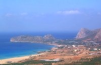 Kissamos, Hania west coast at 16.5km (NW) Falássarna (GR: Φαλάσαρνα)is a quiet resort, with small hotels, apartments and taverns, close to the wonderful sandy beach. There are also many spots for free camping. Falassarna used to be the port of ancient Polyrinia. The peak of the city of Falassarna was during the Hellenistic period and at the time the city had its own coin. Its port was closed and surrounded by walls and it was connected to the sea with a canal.
Image Library
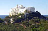
 Kolimbari, Kissamos at 17.4km (N) The monastery of Gonia (GR: Μονή Γωνιάς) or Panagia Odigitria, is located 1 km north of Kolimbari (along the Spatha penninsula) and 24 km from the city of Chania in a wonderful place with a magnificent view to the bay of Hania. It was built in the 17th century, in the Venetian fortress style, and it is dedicated to the Assumption of the Virgin. The monastery replaced an older, 13th-century structure, which was located on the territory of an adjacent cemetery. 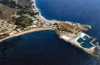 Selino, Hania South West at 18.5km (S) The pearl of the Libyan Sea! Paleochora (population~ 1500) is surrounded by mountains and is situated at the tip of a peninsular. Along the western side is a long sandy beach fringed by trees and tavernas. At the tip of the peninsular is the remains of an old Venetian (Selino Kasteli) fort and a marina. On the eastern side lies the old town, the ferry dock and a long pebble beach lined with tavernas. Paleochora becomes very busy during high season but still have places for those who want to get away from the crowd. Little boats are linking Paleohora with Agia Roumeli, Hora Sfakion and the small island of Gavdos. Regular buses per day are linking Paleohora to Chania (~75kms). Image Library
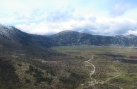 White Mountains, Hania at 18.5km (SE) The famous - mainly due to the gorge of Samaria- plateau of Omalos (GR: Ομαλός) is surrounded by the high crowns of the Lefka Ori (White Mountains) at 1,040 to 1,250 meters and is just 38 km from the town of Chania. It extends to the counties of Sfakia, Selino and Kydonia in the prefecture of Hania. Its shape is nearly rectangular with a perimeter of about 25kms and a diameter of approximately 4 kms. It can be reached by car from the north (Neratzoporo) and from the south (Agios Theodoros).
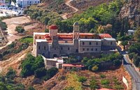
 Hryssoskalitissa, Kissamos South West at 19km (SW) The monastery of Chryssoskalitissa (golden stair GR: Χρυσοσκαλίτισα) is dedicated to the Assumption of the Holy Mother and the Holy Trinity. It is located at the southwest part of Kissamos, 70km away from Chania. The fortress like monastery is built on a rock and pilgrims visiting have to follow a staircase carved on it with 98 steps. According to the tradition, the last one was made of gold but only faithful people could see it.
Image Library
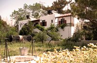 Paleohora at 19.2km (S) Villa Anna is located 100 m. from beach. Villa Anna consists of two separate buildings (each comprising four apartments), surrounded by a rich garden of 2000 sq. m. The apartments are all fully equipped with appliances and comforts: kitchen (complete with fridge/freezer, oven/cook, pots/pans and cutlery), bathroom, living room with TV, A/C and one or two bedrooms. Ideal for comfortable vacations and relax.
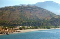 Coastal town in Selino, South Hania at 19.2km (SE) The village of Souyia or Soúgia (GR:Σούγια) is located 75 km southwest of Hania at the southern coast of Crete a little to the east of Paliohora. Sougia is becoming very popular vacation place especially with nature lovers and walkers. There are some ancient sites around and Sougia itself was the port of the ancient town 'Elyros'. There are also quite a few accommodation properties and taverns, a great beach and a small port .
Image Library
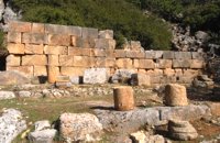 Ancient town in Selino, South Hania at 19.3km (S) Located ~2.3km west of Sougia it was the religious centre of the cities in south-west Crete and the port of Elyros. It flourished during the Hellenistic and Roman periods. In 1957-58 Asklepieion was excavated by N. Platon. The most important monuments of the site are: The Temple of Asklepios, dated to the Hellenistic and Roman periods, Part of a Roman theatre, Rock-cut and built chamber tombs. There two byzantine chapels dedicated to Our Lady and Agios Kirikos The beach in the small cove has coarse pebbles and clear waters. Lissos (GR: Λισσός) nowadays is uninhabited and can be reached from Sougia only by foot (~1& 1/2 hours walk) or by boat (~20 minutes). |
||
|
| ||


C
O
N
T
E
N
T
S
O
N
T
E
N
T
S