interkriti®
YOUR GATEWAY TO CRETE
HOME
CRETE FACTS
NAVIGATE
EXPLORE

Agia Galini
Triopetra
Kissamos
Chryssi Isl.
Agia Marina
Balos
Gavdos isl.
Georgioupolis
SAMARIA
IDA Mtn
Palaiochora
Agia Roumeli
Sfakaki
Bali
Kalamaki
Matala
Lassithi
Plateau Lendas
Tsoutsouros
Vianos
Myrtos
Sfakia
Plakias
Ierapetra
Makrygialos
ZAKROS
Vai
Sitia
Agios Nikolaos
Elounda
MALIA
Hersonissos
Gouves
Chania
Rethymnon
Heraklion
GORTYN
FESTOS
KNOSSOS
|
|
Crete
List Grid Map
Found
152
- Showing :
61 - 80
 Ierapetra, Lassithi at 21.4km (SE) It is a small village with few residents, loacated 4 km to the west of the village Christos at an altitude of 600 m. The residents of Metaxohori (GR: Μεταξοχώρι, or Parsás - GR: Παρσάς) have immigrated to the plains of Ierapetra, in Stomio, Ammoudares and Xerokampos and work in the glasshouses. The village has been renamed in 1955 from Parsas to Metaxohori to honor the Ecumenical Patriarch Meletios Metaxakis who was born here. 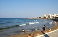 North - East Iraklion at 21.6km (NW) Kokkíni Cháni (Kokkíni Háni - GR: Κοκκίνη Χάνι) is a beach resort located 14km east of the city of Heraklion, on the old national road from Heraklion to Agios Nikolaos. The beach from Vatheianos Kambos, to the west, to Gournes, to the east, is protected by small piers that in some places form small lagoons. It has fine sand and it is clean and well cared, with umbrellas and sun chairs, lifeguards and sea sports. The central street is lined with taverns, restaurants, bars, shops etc while the seaside street is less busy and ideal for walking. Image Library
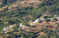
 Ierapetra, Lassithi at 21.6km (E) At a mountainous, precipitous site, in the west mountain slopes of Dikti, at an altitude of 550 m above sea level and at 2 km from the village of Malles, is built the village Christos (GR: Χριστός – Christ). Christos is a beautiful, verdurous village, with many running waters, traditional, unchanged by time, with narrow sloping cobbled alleys. Image Library
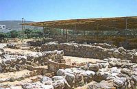 Nirou Chani, North - East Iraklion at 21.9km (NW) A Luxurious, two-storey house, built of large ashlar. The walls were strengthened by timber-frames and covered with a thick layer of plaster and marble slabs. The building has a paved courtyard, a shrine, storerooms for agricultural products, a staircase, and rooms with benches. It has been interpreted as a High Priest's house, due to the numerous ceremonial vessels it contained. The house was probably built in the 16th century. C. (MM III period) and, after its destruction by fire in the 15th century BC (LM IB period), was finally abandoned. The "Minoan Megaron" at Nirou was excavated in 1918 by St. Xanthoudides. In 1960, under the supervision of the Ephor of Antiquities N. Platon, the site was fenced and the building restored. The monument is consolidated and cleared at intervals by the 23rd Ephorate. Visiting Hours: Daily: 8:30-15:00, Monday: closed Entrance Fee:Free Admission 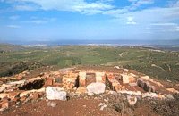 Archanes at 22.1km (NW) Anemóspilia (GR: Aνεμόσπηλια). Anemospilia is an archeological site at the northern foot of Mount Yuchtas, in the prefecture of Heraklion in Crete. A rectangular building has been found which dates from the Minoan era and was destroyed by an earthquake in the 17th century BC. The building with three narrow chambers, each opening into a long corridor to the north, which extends along the whole width of the building. The area is enclosed with a stone wall and the whole structure has been interpreted as a shrine; in the central room was found a "xoanon" (statue) of the deity worshiped here. In the west room, where the altar stood, was uncovered, according to the excavator, the first human sacrifice to have ever taken place in Minoan times. (although this view has been challenged). The building at Anemospelia was used for only half a century, as it was suddenly destroyed by an earthquake in the middle of the 17th century B.C. The site was excavated in the summer of 1979 by John Sakellarakis. 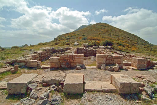 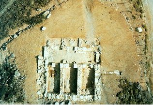 Aerial view 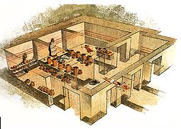 Shrine model Links: Minoan Religion (Foundation of the Hellenic World) 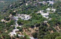 Ierapetra, Lassithi at 22.4km (SE) A small village built at an altitude of 540 m in the south parts of the mountain Dikti at the borders of the province of Ierapetra-Viannos. The imposing mountains above the village, the south horizon among the olive-covered hills and in the lower villages, the cool climate create in you a sensation of bodily and spiritual well-being at this balcony of the Cretan nature. Five settlements, two of them uninhabited today, constituted the Community of Riza, now a Local Department of the Municipality of Ierapetra. 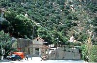 Mirabello, Lassithi at 22.5km (NE) At the side of the gorge of Selinari, at the 42 km. of the national road Iraklion - Agios Nikolaos is the small old chapel and the newly founded monastery of Agios Georgios Selinaris. In the monastery there is also a home for the aged founded in 1963. The small chapel was probably founded early in the 16th century AD, and ever since it is a place of worshiping. The people passing through the chapel stop to light a candle to the saint. The chapel is considered miraculous, there are various legends concerning miracles related either with healing of sick people or with divine punishment of people that did not pay the respect due to the saint.
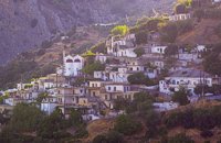
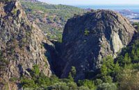 Ierapetra, Lassithi at 22.5km (SE) A monument of natural beauty that attract a lot of local and foreign visitors. The gorge of Sarakina (GR: Σαρακίνα) is one of the most beautiful in Crete. Its steep, vertical walls in some parts reach a height up to 250 m. Its widest opening is no more than 15 metres while in some places it’s so narrow that its sides seem to join each other. Its rich flora and fauna, the dittany, the wild birds that nest there, the running water make the route through the gorge a worthwhile experience. 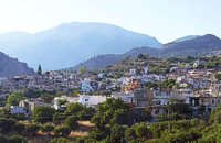 Ierapetra, Lassithi at 22.6km (E) One of the largest villages of Crete, in the north of the valley of the river Sarantapichos. It is 28 km away from Ierapetra and 40 km away from Aghios Nikolaos, in a verdurous slope within immense olive groves, with an unlimited view to the valley of Myrtos, the Libyan Sea and the mountain peaks that surround it. 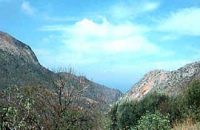 Selinari, Vrahassi at 22.7km (NE) Near the beautiful village of Vrahasi there is the imposing gorge of Selinari, formed by the mountain of Anavlohos (625 m) to the north and the mountain Fonias o Detis (818 m) to the south. The symbol of Crete, the Cretan wild goat (Agrimi or kri-kri) and the Griffon Vulture are two rare species that used to reside in the gorge. The authorities in Vrahasi intend to establish a center of protection of the local fauna and flora at the gorge of Selinari and to develop a wildlife station, to provide observation of the Griffon Vulture colony at the east side of the gorge of Selinari. The hunting is forbidden in an area covering 10 sq.km. around the gorge. 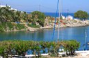 Mirabello, Lassithi at 23km (NE) The village of Sissi, a picturesque village 40 km east of Heraklion and 25 km west of Ag. Nikolaos. Sissi is a beautiful fishing village with strange nature. On one side of the village the nature is wild, with a small river flowing into the sea, a number of palm trees on its banks, ducks and geese swimming peacefully. On the other side there are sandy and gravel beaches, caverns in the rocks and deep clear water, full of many kinds of fish. A place that gathers the nature of different places of Crete.
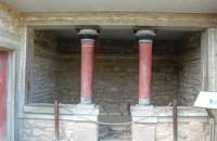 Knossos Palace at 23.5km (S) This house belongs to the New Palace Period (1700-1450 B.C.) and was functionally related to the Palace. In its restored part with two columns, there was a bench on which some object of worship had probably been set up. There was a paved hall in front with a double pier - and - door partition.
Image Library
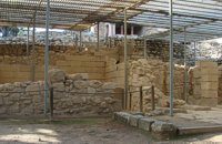 Knossos Palace at 23.5km (S) The south-east house belongs to the New Palace period (1700-1450 B.C.). It was well built and decorated with wall-paintings of lillies. It had a pier-and-door partition, a pillar room and storage rooms. A little behind it are other houses of the Old Palace period (1900-1700 B.C.) such as the house of the "Sacrificed Oxen", named after the remains of a sacrifice found there (horns of a bull and a tripod table of offerings) and the "House of the Fallen Blocks", after the blocks that had fallen from the facade of the palace due to an earthquake. Next to "South-East House" there are houses of the Old Palace period (1900-1700 B.C.), such as that of the "Monolithic Pillars" in front of the steps. Under the small roof is a Minoan, possibly smelting kiln. 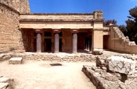 Knossos Palace at 23.5km (S) The "Hall of the Double Axes" was so named by Evans due to the double axe signs engraved on the walls of the light-well at its rear. He also thought that it was the place of residence of the King of Knossos. The central area has openings on three sides and is therefore called a "polythyron" (system with multiple doorways). It has a slab floor and its walls were embellished with gypsum slabs and frescoes. The area between the "polythyron" and the light-well was used as a reception hall. Traces of a wooden construction were found here. Evans reconstructed a wooden throne at this spot. Pictures: 1, 2 According to the archaeological finds, the arrangement of the apartments on the upper floor was similar to those on the ground floor. Image Library
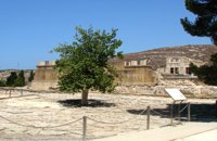
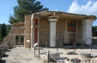
 Palace and Archaeological site at 23.6km (NW) The famous Palace of king Minos and the centre of the Minoan civilisation 5km south of Iraklion. The Great Palace covered an area of 20.000 sq. meters and had 1.400 rooms. Every section of the Palace had a specific use. In the west side of the Palace were the chambers of the ceremonies, of the administration and of the public storehouse...
Image Library
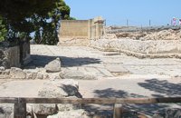
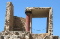
 Knossos Palace at 23.6km (S) The court is crossed by the so-called "Processional Causeways", which stand out from the rest of the paving and intersect each other. One idea is that processions paraded along them during ceremonies. The West Facade of the Palace rises up along one side. The facade is constructed of massive gypsum blocks (orthostats) set on a plinth. The facade is indented or protrudes corresponding to the interior arrangement of space. In front of the West Façade, two bases can be seen, thought to belong to stone-built altars. Settlement remains of the Neolithic (6700 - 3200 B.C.) and pre-palatial (3200 - 1900 B.C.) periods have been found beneath the level of the "West Court". Image Library
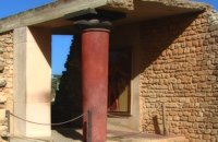
 Knossos Palace at 23.6km (S) The "West Porch" was a roofed area opening onto the Court, supported by one column of which part of the gypsum base remains. The east wall was decorated with a bull-leaping fresco. There was a small "guard-room" at the back. The porch was closed off by a double door and from here began the long "Corridor of the Procession". Image Library
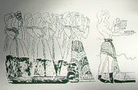 Knossos Palace at 23.6km (S) The Corridor of the Procession is named from the wall painting decorating its east wall and depicting a procession of musicians and other people holding gifts. The floor was very fine. The "Corridor of the Procession", according to Evans, initially led to the "South Propylaeum" and continued on to the Central Court. Today a causeway made of wood, with handrail, stands in its place, so the visitors can follow the same route. Image Library
 Knossos Palace at 23.6km (S) The "South Propylaeum", as we see it today, is a result of the restoration of Evans who put up a copy of the "Cup-Bearer" fresco here. The wall painting depicted a man holding a libation vase (rhyton). Its theme is connected with the "Procession Fresco" which, according to Evans, reached here, the "South Propylaeum". The pithoi (large storage jars) on the east side of the Propylaeum belong to the Postpalatial Period (1450-1100 B.C.), and indicate that the area was later used for storage.
Image Library
 Knossos Palace at 23.6km (S) The south part and south facade of the palace is very eroded. Today one can only see foundations on tiered levels. At the bottom, a tower-like projection is all that remains of the south entrance to the Palace. An asceding corridor led to the Central Court. The section of the corridor closest to the Central Court was reconstructed by Evans who put here a copy of a relief wall painting, of which only few fragments were found. On these fragments, it was possible to make out a figure wearing jewellery in the shape of lilies. The reconstruction we see here is uncertain. In Evans's opinion, it represented the "Priest-King". Other scholars think that it is a prince, whilst others believe it depicts a female figure. Anyway the original fresco which is known as the "Prince of Lilies" is one of the masterpieces in the collection of the Heraklion Museum. Image Library
|
||
|
| ||


;)
;)
C
O
N
T
E
N
T
S
O
N
T
E
N
T
S