interkriti®
YOUR GATEWAY TO CRETE
HOME
CRETE FACTS
NAVIGATE
EXPLORE

Agia Galini
Triopetra
Kissamos
Chryssi Isl.
Agia Marina
Balos
Gavdos isl.
Georgioupolis
SAMARIA
IDA Mtn
Palaiochora
Agia Roumeli
Sfakaki
Bali
Kalamaki
Matala
Lassithi
Plateau Lendas
Tsoutsouros
Vianos
Myrtos
Sfakia
Plakias
Ierapetra
Makrygialos
ZAKROS
Vai
Sitia
Agios Nikolaos
Elounda
MALIA
Hersonissos
Gouves
Chania
Rethymnon
Heraklion
GORTYN
FESTOS
KNOSSOS
|
|
Crete
List Grid Map
Found
180
- Showing :
141 - 160
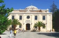 Iraklion Old Town at 22.9km (NE) With the recovery of Crete from Nikiforos Fokas (961AD), the seat of the bishopric is transferred from Gortyna to Chandakas, which became the capital of the island. The new cathedral, which is the most established and largest in the city, is dedicated to the Apostle Titos. Here, amongst other relics, there are gathered the Holy Skull of the Apostle and the miracle working icon of Messopapaditissas. Image Library
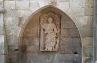 Iraklion Old Town at 22.9km (NE) It was made by Giovanni Sagredo between 1602-1604, part of it has been built in the Northwest corner of today's Loggia (Town Hall) and it is decorated with a carved female statue which according to Gerola's description probably with the left hand she was holding a shield, while with the right one a kind of a big hammer for display, representing the personification of Crete.
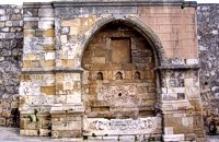 Iraklion at 22.9km (NE) It is in the Ikarou Avenue, next to the Epigraphic Collection of Heraklion Museum. Within an arched construction which, is surrounded by two big square columns, decorated with rosettes, there is a relief spout of fine workmanship. The water is gathered in a marble basin adorned by a richly decorated relief. Image Library
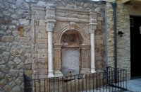 Iraklion Old Town at 22.9km (NE) It was built in the end of the 17th century. Today it is found behind the Historical Museum of the city. It is decorated with two columns with floral capitals, while in between them and inside an arched construction there is a marble plaque with relief decoration. The water was running from a specially made hole at the bottom of the plaque, into a marble basin.
Image Library
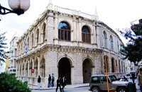 Heraklion old town at 22.9km (NE) It is an essential public building in every Venetian city, which was not absent even from the colonies. For Candia, Loggia is considered to be one of the most elegant architectural monuments of the Venetian period, a representative sample of the palladian style. During the Venetian period, Loggia was the official meeting place of sovereigns and nobility where they discussed various topics that had to do with economic matters, commercial, and political ones.
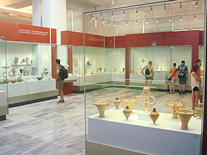 Heraklion city at 23km (NE) The most magnificent collection of Minoan art and culture in the world, unique in beauty and completeness is housed in this museum. The exhibiton of the museum is organized in chronological order, ranging from the Neolithic period to the Roman era (4th century A.D.) and geographically, according to the provenance of the finds.
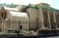 Iraklion Old Town at 23km (NE) It is situated approximately in the middle of the seaside wall. It was built from the first years of the venetian domination and belonged to the monastic order of Dominicans (Domenicani Predicatori). It was one of the most important and biggest Catholic monasteries of the city. The earthquake of 1508 caused a lot of damages to the temple. It consists of a long aisle which is roofed by a two slope roof and ends at a sanctuary roofed by two vaults. To the north and south wall of the temple there are windows of different types that were opened either during the Turkish period, or even earlier. Image Library
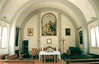 Heraklion Old Town at 23.1km (NE) The Heraklion Catholic church is located at 2, Patros Antoniou street close to the old port of the city. It is dedicated to Saint John the Baptist and was first built in 1888. In the 1959 earthquake the church suffered serious damages and had to be demolished and rebuilt. The pastor at that time, Father George Roussos, built the present church in 1961-1962. Father Petros Roussos, who was Pastor from 1980 to 2008 refurbished also the Capuchin Monastery that stands next to the church. 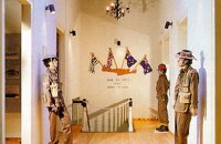 Heraklion at 23.1km (NE) The Museum of the Battle of Crete and National Resistance (1941-1945) was founded by the Municipality of Heraklion in May 1994.The museum's aim is to collect, preserve and exhibit relics from 1941-1945 in an appropriate manner, as well as to document and disseminate information on the people's struggle during the Battle of Crete and the German-Italian occupation. In addition to presenting a range of material witnesses to the past, the museum aims to cultivate interest and respect for the history of Crete. Contact details: Doukos Beaufort and Merambellou Str. Tel. (+30)2810 246 554 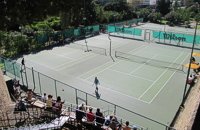 Iraklion at 23.2km (NE) The Club was founded in 1928 by Stelios and Stefanos Perdikojiannis, Meletis Kokkinakis, and Nikos Pandelakis. Until 1940 it was operating as an independent part of the Union of Athletic Associations of Iraklion, having Mr George Voiolas as president. In 1946 it became an independent club under the name "Tennis Organization of Iraklion" , commonly "TENNIS", with department of tennis and table tennis. Later in 1968 two more departments were added, basketball and volleyball, and finally the department of chess in 1978. In 1975 the club was renamed to "Iraklion Sports Club". Today the most active departments are: Basketball, Tennis, Table tennis, Chess. Links: Official Site 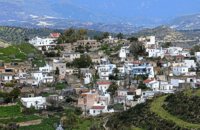 Messara, Iraklion South at 23.2km (SW) Kamilari is a quiet, traditional village, with a panoramic view to the endless olive groves of the Messara valley on the one side, and to the Libyan sea on the other side. It has been inhabited since the Minoan period. One of the seven wise men of the ancient world, Epimenidis, a great wise man and a soothsayer, lived in a small community outside Kamilari, called Metohi.
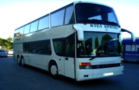 Heraklion Port at 23.3km (NE) Crete Public Bus Services (KTEL) with modern air conditioned buses and experienced personnel, offer travelling people, secured, comfortable, quick & affordable transportation almost to the most remote spot of the island. The bus station at Iraklion is situated at the port only a few minutes walk from the town's center. Timetables : East Crete Timetables-KTEL Heraklio - Lassithi West Crete Timetables-KTEL Hania - Rethymnon 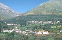 Mylopotamos, Rethymno at 23.4km (NW) Apladianá (GR: Απλαδιανά) is a small village built at the foot of the two Kouloukona heights. The settlement stretches out along the old national road, where it developed after the opening of the new national road. It comprises cafes, tavernas, and accommodation facilities included in the Countryside Tourism programs. It is worth your while, however, to visit the old village, climbing there on foot or by car. Picturesque, narrow streets, wonderful old houses with interesting architectural elements, old cisterns and churches will reward your efforts. The old village built on a height of 260 m above sea-level has 175 inhabitants and the settlement along the old national road, known as "Kampos ton Apladianon", has 78 inhabitants. It is 40 kilometres away from Rethymnon and is located at the foot of the highest peak of the Kouloukona mountain in the Tallaios range. Historical background Already as far back as 1368 we find a mention of the Aplada family, the founders of the present village and in the topographical maps of the Civil Engineering Services of Rethymnon it figures as Pladiana. The settlement is not mentioned in the 16th and 17th cent. documents. In the 1881 census, Apladiana is attributed to the commune of Garazo, with 57 inhabitants and in 1900 it is referred to as the Apladiana Commune which, together with the Cheliana settlement, had 153 inhabitants. 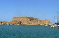 Iraklion Venetian port at 23.5km (NE) A seaside fortress situated at the entrance of the old harbour. It was built by the Venetians, before the construction of the new Venetian fortification, in order to protect the pier and the port. It took its last shape in the years between 1523 - 1540 replacing another construction destroyed by an earthquake. Image Library
 Messara, Iraklion South at 23.5km (SW) Its 1000 years history comes to life for the visitor, who has the chance to admire its monuments, and old houses, perfectly preserved through the centuries. In the village square , you can sit and enjoy your coffee in the traditional coffee shop, while children can play in the playground next to the school. You can also visit the church of Agios Ioannis in the same square. There are quite few rooms for rent in the village and tavernas serving traditional Cretan dishes.
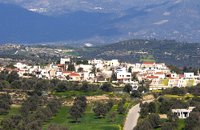
 Malevizi, North - West Iraklion at 23.6km (N) Ahláda (GR: Αχλάδα) is a small village located 24 kms west of Iraklion at an altitude of 300 meters a.s.l. It is close to the tourist resorts of Agia Pelagia and Ligaria, and it has approximately 500 inhabitants, most of them farmers and stock breeders. The name of the village meaning wild pear tree is given probably due to the huge wild pear tree that used to be at the village.  Iraklion at 23.9km (NE) Since 1985, with hard work, we have managed to become well known and trusted car hire company, not only in Crete but also amongst our numerous customers from Europe and other countries. We are the cheapest in town. We deliver to port, airport and hotels. Full insurance without excess. - New models, Safe Cars, Special Offers. No deposit required for booking. 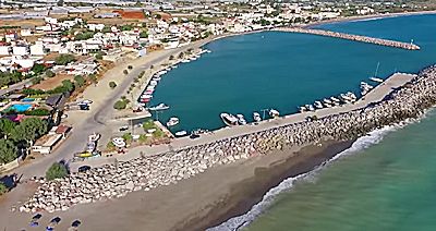 Messara bay, Iraklion South at 23.9km (SW) Kokkinos Pirgos (GR: Κόκκινος Πύργος) is a small coastal community, 2km away from Timbaki with a nice, long sandy beach, one of the longest in Crete, and a clear transparent sea. The part of the beach to the north west of the harbour is called Makrimaliana (or Kakoskalo) and the south east part of it is called Katalyki . The harbour in front of the village of Kokkinos Pirgos, offers docking facilities for sailing and fishing boats. There are hotels, restaurants, bars, etc. across the harbour and along the beach. You can always find good fresh fish in the taverns of the village. Kokkinos Pirgos (meaning red tower) , took its name from a castle that use to be there during the Middle Ages, which was built by red clay earth.
Image Library
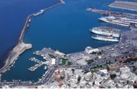 Iraklion at 24.4km (NE) The Port of Heraklion is the main and most modern gateway for the transport of passengers and commodities on the island of Crete. There are three main companies that connect Iraklion to mainland Greece, Minoan Lines, Superfast Ferries and ANEK. During the winter months there are daily trips from Athens to Iraklion. The trip takes approximately 6 - 9 hours by ferry boat. The ships depart Athens in the evening (10.30 p.m.) and arrive in Iraklion at 5:00 - 6:00 a.m. There is also a weekly trip to Thessaloniki. During the summer season all companies operate also an extra daily trip that departs in the morning from Athens and arrives at Iraklion port in the afternoon. Finally various other companies operate ships connecting Iraklion with other island in the Aegean (Rodos, Santorini etc.). Daily cruises are also offered to the island of Santorini. Image Library
 Agia Pelagia, Maleviziou, Iraklion N-W at 24.5km (N) Lygaria (also Ligaria GR: Λυγαριά) is a small seaside resort 2 kms to the east of Agia Pelagia. It is built in a small cove with a lovely sandy beach protected from the summer winds (Meltemi). Lygaria started as a residential area comprising of summer houses built mainly by residents of Heraklion but soon it has developed to a tourist resort. It has a couple of small taverns, hotels and cafes by the beach and it is very popular with tourists and locals alike. There is regular public bus transport from Heraklion. The distance from Heraklion is 19 kilometers via the national road.
Image Library
|
||
|
| ||


C
O
N
T
E
N
T
S
O
N
T
E
N
T
S