Sitia to Makrygialos
  |
|
|
|
|
|
|
|
|
|
|
|
|
|
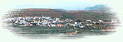
| Driving from Sitia to Makrygialos |
The village is mentioned at the census of 1577 by Fr. Barozzi, and became the seat of the commanding officer, after the destruction of the town of Sitia in 1538 by the pirate Chairentin Barbarossa.
Continuing our route to the mainland, we pass from the small chapel of "Agios Ioannis o Prodromos" and at the 8.5th km, from the village Maronia built by the soldiers of Nikoforos Fokas who probably came from Maronia of Thrace.
A few kilometers further at the village Pano Episkopi the road splits in two: to the left the road leads to the ancient PRAISSOS and the village of Ziros.
Between the villages Sykia and Andromyloi, N.Platon unearthed in 1954 vaulted tombs of the Late Minoan period and two houses at a place named "Monastiraki". A large number of findings were also discovered.
Papagiannades is the next village that we meet on our way to Ierapetra, located 19 km away from Sitia at 480m a.s.l.
eaving the town of Sitia we take the road to Ierapetra driving through the mainland to the southern coast of the county.L
The first village that we meet is Piskokefalo, a principal village located 3 km south of Sitia.
Piskokefalo is the birth place of the great poet Vincentzos Kornaros, who wrote the masterpiece of Medieval poetry, "Erotokritos". This poem of 10,000 lines narrates the love story of the princess Aretousa, daughter of the king of Athens Hercules, and Erotokritos, son of Pezostratos, member of the king's court. You can meet even today people who can recite large parts of it by heart.
The brother of Vincentzos, Andreas Kornaros was also a man of letters (he wrote the history of Crete).
Prof. N.Platon who unearthed the palace of Zakros believed that at the nearby hill of Katrinia there were a peak sanctuary of the Minoan III period, which was of the same significance with this of Petsofa. At the surrounding area there were discovered a large number of findings of the Neopalatial period.
Nowadays Piskokefalo is a beautiful village where a stop is worthwhile. The visitor can see the house of Kornaros, enjoy a coffee or a meal at the village's square, visit the spring at Zou, the old water mill, the church of "Agia Anna" and the small chapel of "Panagia Trapezounta".
The main products of the village are olive oil of superior quality and wine.
Four km away from the cross road in a tree-covered place stands the tavern "Spring of Paradise" with good food and service.
o the right the road continues to Ierapetra and at the16th km from Sitia stands the village "Sykia" (the name comes from the fig-tree= sykia). Here a couple of taverns serve quick meal.T
A little before the village at the top of the hill "Ai Lias" was discovered a peak sanctuary.
At the small chapel of "Panagia Eleoussa" built in the 14th century, we can see well preserved frescoes.
From Papagiannades starts the river Pantelis which flows through the tree covered valley of the same name. A visit to this valley is worthwhile and the municipality has provided a spot with certain facilities (barbecues, running water and so on) for the visitors. A little further stands the small chapel of Panagia.
We are taking now the down hill road to the southern coast and after the villages Lithines and Pilalimata at the 33rd km from Sitia we find a crossroad.
The road to the left leads after some 8 km to the Kapsa monastery and the coastal settlement Kalo Nero passing from the wonderful sandy beach of Psalidia and the small secluded one of Ammoudi.
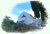
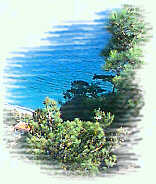
| The Kapsa Monastery |
| The Monastery of Kapsa is located 40 km from the town of Sitia at the exit of the Pervolakia Gorge built on the steep rocks overlooking the Libyan sea. The exact time of the foundation of the monastery is still unknown, while some believe that it was in the 15th century. Until 1841 there were only a small chapel dedicated to the Saint John the Baptist and a few cells. The glorious period of the monastery is connected with the activities of a crook of the time named "GERONTOYANNIS" (Yannis Vitsentzos). He had been using the monastery as a hideout when he believed that he could make money by curing people! It was rumoured that he had Divine visions and with the help of the God he was able to cure the pilgrims (only the really faithfull) of any illness. A large number of people started then visiting the monastery, bringing lots of gifts and Gerontoyannis spent a lot of them to built new cells and a second chapel dedicated this time to the Holly Trinity. A renowned craftsman of the time, Hatzi Minas, made the splendid wooden temples (1869) and Antonis Alexandridis made the beautiful icons (1870). Gerontoyannis who was married died in 1874 at the age of 75. His grandson Iosif many years later came to the monastery to continue his grandfather's work. He added some new cells, brought running water to the monastery and cultivated the surrounding gardens. The monastery celebrates every year in August 29, name day of Saint John. |
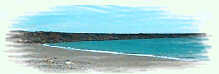
The main road leads after one km at the coastal resort Makrygialos (=long beach). Makrygialos is the most tourist developed area of the county of Sitia, with all kinds of accommodation and facilities.
In the summertime there are scheduled cruises to the small island "Koufonissi"
A minoan villa was unearthed near Makrygialos. This villa built probably near 1600 B.C. in a style of the Minoan Palaces, used to be the residence of a local lord. Excavations have not been completed yet and the place is enclosed.
A visit to the place however is worthwhile. Nearby is the beautiful beach of Kalamoukanias.
| F |
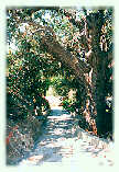 A little before the entrance of the village we find a detailed map of the area with the recommended places to visit, the walking path through the "pefkiano" gorge and the provided spots for rest and relaxation.
Pictures
.

|
Top |
|
| Map | Road Map |
| Regional Index | Bulletin Board |

