interkriti®
YOUR GATEWAY TO CRETE
HOME
CRETE FACTS
NAVIGATE
EXPLORE

Agia Galini
Triopetra
Kissamos
Chryssi Isl.
Agia Marina
Balos
Gavdos isl.
Georgioupolis
SAMARIA
IDA Mtn
Palaiochora
Agia Roumeli
Sfakaki
Bali
Kalamaki
Matala
Lassithi
Plateau Lendas
Tsoutsouros
Vianos
Myrtos
Sfakia
Plakias
Ierapetra
Makrygialos
ZAKROS
Vai
Sitia
Agios Nikolaos
Elounda
MALIA
Hersonissos
Gouves
Chania
Rethymnon
Heraklion
GORTYN
FESTOS
KNOSSOS
|
|
Crete
: Geography & Nature
List Grid Map
Found
5
- Showing :
1 - 5
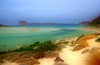 Gramvoussa Cape, Kissamos West of Kissamos and north of the beautiful village of Kaliviani, stretches the impressive Gramvoussa peninsula. The peninsula is formed by steep rocks and is covered with thyme and origanum bushes and wild flowers. On the north west side of the peninsula opposite to the island of Gramvoussa is the wonderful beach of Balos (GR: Μπάλος). The beach is covered with fine white sand and is located between the two creeks of the Tigani cape. The same white sand covers the bottom of the sea and grants to the sea an emerald color. In front of the beach is the picturesque island of Gramvoussa and on the back is the Geroskinos mountain (altitude 762 m). The road from Kaliviani is well paved dirt road, with amazing view to the steep rocky seaside of the east side of the peninsula. The road ends one-two km before the beach, and the visitor can follow a paved road to Balos. North of Balos, at the Korykon cape, are the ruins of the small Roman city of Agnion, with a temple of the God Apollo. There are small boats, offering daily cruises to Balos and Gramvoussa, departing from Kissamos (Kastelli) during the summertime. Image Library
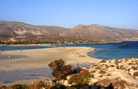 South west Kissamos Elafonissi is a small islet on the southwest of Crete. It is connected to the beach with a shallow reef (max. depth 1 meter) that allows crossing when the sea is calm. There are only a couple of cantinas on the beach and plenty of places for camping. The place can be accessed by car from the village of Vathi or by boat from Paleohora. There are no permanent inhabitants.
Image Library
 Kissamos A small village 21km away from Kastelli Kissamou,at 340 m. a.s.l with 57 permanent residents. The village is mentioned by Fr. Barozzi since 1577. A little before the village of Sassalos, starts the gorge of Salasse, a small one which leads to Tyflos river, and is worthy to walk.
 Kissamos Sirikari (GR Σηρικάρι) is a small village located 52 km away from Hania and 14 km from Kastelli at 500m a.s.l. The name Sirikari probably comes from the profession of the first settler, who has to be a silk weaver (Sirikaris). A short ravine starts from Sirikari and ends close to Polyrinia. There is also a chestnut tree forest, the cave of the Holy Mother (Panagias), the byzantine church of Agii Apostoli, with frescoes of 14th century a monument of great importance and two old factories. 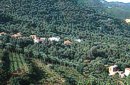 Kissamos, Hania Vlatos is located at 380m a.s.l., 54 km away from Hania and 18 km from Kastelli Kissamou. It is built in a tree covered valley, with olive trees, chestnut trees and wild vegetation. There are some very nice trekking paths around and in the forest of "Peace" which has been characterized as a natural park. The "Park of Peace" was founded in 1970 by the Cultural Association of Vlatos with the cooparation of Goethe Institute and the support of the Bavarian Department of Forests. It is an experimental park with 150 species of plants, covers an area of 1,000,000 sq.m. and is part of an extended area of 20 sq.km. which have been reforested. 1
|
||
|
| ||


C
O
N
T
E
N
T
S
O
N
T
E
N
T
S