HOME
EXPLORE
Samaria Gorge
Sfakia, South Hania
Home
Map

The National park of Samaria is the only one in Crete
and is designated a Biosphere Reserve by UNESCO
The Gorge of Samariá (GR: Φαράγγι Σαμαριάς) is located in the south-west Lefká óri (GR: Λευκά όρη = White Mountains) in the province of Sfakia of the Hania prefecture.
It is surrounded by high mountain peaks such as Gigilos (2080m), Volakias (2116m), Melindaou (2153m), Avlimonakas (1806m) and others, that delimit the area of the National Park Of Samaria which is 4,848 hectares - 1 hectare (ha) = 10,000 square metres = 10 strémmata. Its width ranges from 3 to 300 metres and its height from 200 to 1000 metres. Its northern (high) entrance is at an altitude of ~1250 m. at Xylóskalo (GR: Ξυλόσκαλο), in the plateau of Omalós and its southern entrance 3.2 km north of the village of Agia Roumeli on the south shores of Sfakia. Its length along the pathway and within the limits of the park is 12.8 km, which makes a total of 16km from Xyloskalo to Agia Roumeli. The Samarian Gorge is one of the longest ravines in Europe.
The river Tarraios ( named after the ancient city of Tarra that used to be where Agia Roumeli is today) runs the entire length of the gorge.
The protected environment, the abundance of water, the topography and the climate that ranges from alpine to subtropical, make Samaria a paradise for wildlife. There is plenty of plant species from century old trees, to wild flowers and herbs, some of them very rare like the Cretan maple, orchids, dittany and others. Rare species of birds like vultures and eagles, and mammals like the Cretan ibex, known as Kri-Kri, live here.
The gorge was continuously inhabited since the antiquity. Due to the richness and the good quality of its wood and the greatness of the landscape, Samaria became a center of economic activity and a cult place as well. Timber was exported to Egypt and other countries and is said that even pillars in the palaces of Knossos and Mycenae were made of cypress trees from Samaria. Ancient temples were found not only in Tarra, the ancient city at the exit of the gorge, but also in many places within the gorge itself. The ancient town Kainó (GR: Καινώ) used to be a little further from where the church of Agios Nikolaos lies today.
The village of Samaria located in the middle of the gorge was inhabited even until 1962 when the area was declared a national park.
During the many struggles of Cretans for their freedom, the gorge, was a secure hide-out and the base of operations of the freedom fighters. Various stories and legends link those difficult times to Samaria.
Image Library


Visitors' Information
Visitors usually walk the gorge from Xylóskalo, in Omalos, to Agia Roumeli. The best way to reach Omalos is by public bus, or join an organised group.
At the entrance of the gorge there are two tourist pavilions with café - restaurants, the information office and parking area.
Agia Roumeli is an isolated small village connected to the rest of Crete only with sea lines. There are no cars nor bikes. The only option - except for walking - that visitors have in order to get back to their base is to take the boat. There are frequent schedules to Sfakia (Hora), Paleohora and Sougia.

Samaria National Park
Entrance fee: 5 €
Period: May 1st - October 15th
from 6:00 am to 3:00pm

Telephone: +30 28210 84211
e-mail : ddchania@otenet.gr

Rules

The Gorge is open to visitors from May to October 15th. Depending on the weather the period may be extended until the end of October. Closures can occur during this period in case of rains, strong winds or any other danger. This is mainly for safety reasons, to protect visitors in case of rockfall, river overflow, fire etc.
The best time to walk the Samaria gorge is probably May, early June and late September, October. At these times, there are less people visiting the gorge, the weather is mild and the nature is at its best.
During the day the park is open from 6 o' clock in the morning until 3 o' clock in the afternoon. After 3:00pm the visitors may enter the gorge but are allowed to walk only the first two kilometers (from both sides).

Walking through the gorge is an experience that all visitors should enjoy.
The park authorities have put a set of rules to ensure visitor's enjoyment and safety and the protection of this magnificent natural monument.
People have been known to walk through it in 3-4 hours, but a more sedate pace, would allow the visitor, time to enjoy it more.
Usually people start their walk at 7-8 in the morning and come out to the beach at about 4 o' clock in the afternoon.
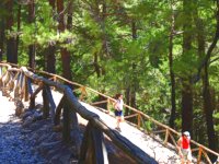
Walking is allowed only along the signposted trail, in order to limit the disturbance to the natural habitats and wildlife species. Park wardens, equipped with walkie - talkies, constantly patrol the gorge and are always available for assistance. Stopping for a break is only allowed on certain resting points every 2-3 kilometers.
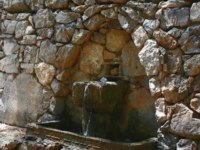
There are many well maintained springs with fresh water, along the gorge, where visitors can drink water and fill up their water flasks. Toilets are also in several spots.

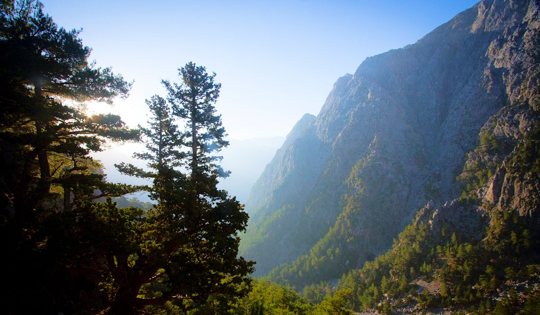
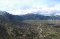
The path from Xyloskalo (1250m alt), descends following the steep slope until the bottom of the gorge where it meets the riverbed. This part of the path has steps and wooden handrail. It is in the shade of tall trees and at several points offers spectacular views. It is hard though for those with knee problems.
Halfway through the park lies the village of Samaria about 7.5kms from Xyloskalo. 
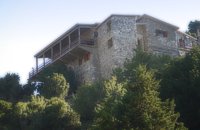
Here is the main resting point where visitors usually stop for a while, to get some rest at the benches and stroll around the village's old houses and churches. Some of those houses are restored and are being used as the guards' post, the doctor's office and the information kiosk which is housed in the old olive press. There is also a heliport for emergencies.
Chances are that individuals of the famous Kri-Kri (The feral goat of Crete) will be seen in the surroundings, especially young animals, which are less shy.
At the village's edge lies the byzantine church of "Osia Maria of Egypt". The name Samaria is quite likely a corruption of that name.
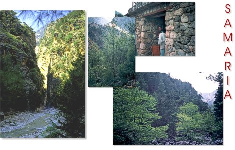
After the deserted village, follows the most impressive part of the gorge, with high walls, narrow passages and interesting geological formations. The path continues either parallel or crossing the river several times, where visitors, in most cases, have to step on big stones in order cross the river. The temperature also reaches high levels in this part.
At the 11th km lie the famous "Pόrtes" or "Siderόportes" (Gates or Iron Gates) where the sheer rock walls rise to 300 m leaving a passage only 3.5m wide.
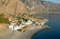
After the "Gates" the gorge widens and there is only 1.5 km left until the exit of the park and then another 3.5km, through the deserted village of Old Agia Roumeli to the beach.

Although relatively easy, the crossing of the Samarian Gorge, is still a 16 km long walk, on stony and uneven terrain and it is, undoubtedly, a hard test for anyone's body.

People who are planning to do the walk should be in good physical shape and well prepared. Those who have problems with their knees, or the extensive heat should avoid the walk or choose to do the "Easy Way".


Suggested Outfit
  • The most important are the shoes. Preferably sport shoes with thick soles or even better hiking boots.
  • A rucksack
  • A water flask or a plastic bottle for drinkable water.
  • A hat and sun burn protection.
  • A jumper or a jacket as in early morning it's chilly even in August at the altitude of 1250m.
  • A sandwich or snacks
  • A walking stick will help.
  • A camera with fully charged batteries.


Public Buses
Hania - Omalos
Daily at 08:30 & 14:00
Travel time: ~45 minutes
Kastelli - Omalos
Daily at 06:00 & 07:00
Sfakia - Hania:
Duration: ~2hrs
Departs after the arrival of the boat.
KTEL public Buses' website


Boats
Ag. Roumeli - Sfakia
Departure: daily at 17:30
Boats' website
In and around
Show All
Tourism facilities
Regional interest
Towns & Villages
Sightseeing
Beaches
Kallergi%20refuge%20
Kallergi refuge
Lefka Ori, Hania
at 2.8km (NW)
Xyloskalo
Xyloskalo
Omalos, Hania
at 3.2km (W)
Omal%CF%8Cs%20Plateau
Omalόs Plateau
White Mountains, Hania
at 6.2km (NW)
Agia%20Roum%C3%A9li%20village%20%2D%20Tarra
Agia Rouméli village - Tarra
Sfakia, South Hania
at 8.2km (S)
<
...
>
Home
Map

Contact Us
© 2024 interkriti.org