interkriti®
YOUR GATEWAY TO CRETE
HOME
CRETE FACTS
NAVIGATE
EXPLORE

Agia Galini
Triopetra
Kissamos
Chryssi Isl.
Agia Marina
Balos
Gavdos isl.
Georgioupolis
SAMARIA
IDA Mtn
Palaiochora
Agia Roumeli
Sfakaki
Bali
Kalamaki
Matala
Lassithi
Plateau Lendas
Tsoutsouros
Vianos
Myrtos
Sfakia
Plakias
Ierapetra
Makrygialos
ZAKROS
Vai
Sitia
Agios Nikolaos
Elounda
MALIA
Hersonissos
Gouves
Chania
Rethymnon
Heraklion
GORTYN
FESTOS
KNOSSOS
|
|
Crete
: Towns & Villages
List Grid Map
Found
148
- Showing :
41 - 60
 Sitia south Makry Gialos (Long shore GR:Μακρύ Γιαλός) is a small beach resort on the south-east coast of Crete, located 60km from Agios Nikolaos, 25km from Ierapetra, and 33 km from Sitia. Makry Gialos features a small fishing harbour and a nice 1km long sandy beach that stretches from the harbour to the east. Four more lovely beaches can be found in the immediate area. Accommodation is available mostly in family-run studio and apartment complexes and there is a good choice of bars, restaurants, tavernas, some of them right on the beach front or at the small fishing harbour. Makry Gialos is the administrative centre of the wider area which comprises some picturesque traditional villages built on the tree covered mountain sides. The area has been inhabited since the Minoan times as many ruins from this as well as the Roman and the Venetian periods prove.  Spili, Rethymno Spili (GR:Σπήλι) is 30 km away from Rethymnon, along the road that goes from Rethymnon to Armenoi and then Spili. The town has about 800 inhabitants and it lies at a height of 430 m above sea level, at the foothills of Mount Vorizi, which belongs to the Kedros chain. The landmark of the town is the square at Kefalovrissi with the 25 fountains each one in the shape of a lion's head. The square is named after Thanassis Skordalos (1920-1998), a popular lyra player and composer born in Spili. Spili is a modern town, with all the facilities and services required by the locals and by the large number of visitors. Image Library
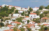
 Mirabello, Lasstithi Kritsa is one of the most picturesque towns in Crete, built amphitheatrically on a rock hill. It is located 11 km from Agios Nikolaos and has 2000 inhabitants. The people keep the old Cretan customs and the traditions and the town is considered one of the most important centers of the Cretan folk and weaving art.
 Mylopotamos, Rethymno Margarites (GR: Μαργαρίτες) with 300 inhabitants, is located 27 kilometers from Rethymnon at 300 m above sea level near the amcient town of Eleftherna. Margarites, is a village with Venetian roots, mentioned by sixteenth-century travellers. In the nineteenth century, Margarites was a flourishing town, whose centuries-old ceramic tradition began at least as early as the Ottoman period. Margarites is undoubtedly the most important pottery centre in western Crete. 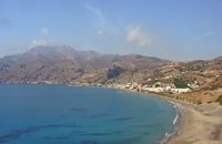 Monofatsi, South Iraklion Tsoutsouros (GR: Τσούτσουρος) is a small village on the southern coast of Iraklion prefecture, with lovely beaches and a small harbour. The ancient city of Inatos, used to stand were Tsoutsouros is now. Inatos served as a port to Priansos a renowned city - state of the Hellenistic time, located near the village of Kasteliana. Tsoutsouros is a popular tourist resort especially with Greek families. There are many taverns and cafes most of them around the small harbour, and a good choice of apartments and hotels along the beach. Image Library
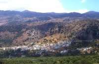
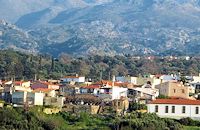
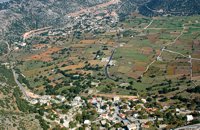
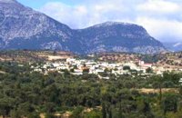
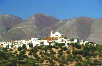 Sitia, East Crete The village of Tourloti (GR: Τουρλωτή) is located in Eastern Crete, on the road from Agios Nikolaos to Sitia. Tourloti is 42 km from Agios Nikolaos and 27 Km from Sitia. Tourloti is a small, traditional village, the largest of a group of four, dotted across the hillsides in this area. It has changed little in the past few decades, and remains untouched by tourism. However, it retains a healthy vibrant Greek community, of families living and working in the local area. The village has a prominent church, primary school, two small mini-markets, a bakery, chemist, post office, two kafenions and one small traditional taverna. The narrow streets with white washed houses, flower filled alleyways, and glimpses of spectacular views, give the village a unique, timeless sense of tranquility, far removed from modern city life. It is the centre for several religious celebrations and festivals, especially over Easter and the summer months. 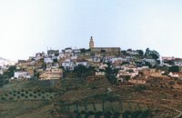 Malevizi, Iraklion Agios Myron, with 708 inhabitants, lies 18 km from the city of Iraklion to the south west. Its one of the most important villages of the area with interesting town planning and impressive samples of traditional architecture. Built between two hills it commands a panoramic view and the school's clock, its main characteristic, is visible from almost everywhere in the area of Malevizi. 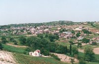 Kenouriou, Iraklion Megali Vrissi (GR: Μεγάλη Βρύση) lies 32km south of Heraklion, at 620 m above sea level. In the Barozzi document of 1577, it is mentioned as forming part of the province of Monofatsi and, in the Archives of Megalo Kastro (Heraklion), it is quoted in 1583 as having 71 inhabitants; there is also a reference to the village in the Basilicata document of 1630. The Turkish census records it with 47 families in 1671, and in the Egyptian one in 1834, it figures with 27 families. In the censi of 1881 and 1900 it is mentioned as a municipality in its own right with, respectively, 240 inhabitants and 307 inhabitants. As of 1928, it becomes a commune and today it counts over 900 inhabitants. Saint Constantine is the patron saint of the village. The churches of Aghia Anna and of the Panagia Almiri are worth visiting. The Aeolian Park, one of the islands pioneering projects, has been installed in Megali Vrisi and produces electricity of 5MW. 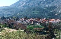 Malevizi, Iraklion Ano Asites (GR: Ανω Ασίτες) lies 24km from Iraklion and 6km from Agios Myron at 480m a.s.l with 423 inhabitants. A big part of the surrounding area is covered by forest on the eastern side of the mountain Psiloritis. Near the village there is the Byzantine chapel of Agios Antonios located in the ravine with the same name a place of exceptional natural beauty. From here passes the European Hiking Path (E4) which leads to the shelter "Prinos" ( of the Mountaineering Club of Iraklion - altitude 1100 m a.s.l.) located in a holly (=prinos) forest. 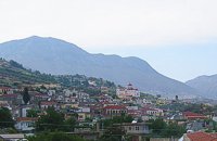 Malevizi, Iraklion Kato Asites (GR: Κάτω Ασίτες lies 23km from Iraklion and 5km from Agios Myron at 450m a.s.l with 1113 inhabitants. Beautiful town with traditional architecture especially the quarters "Notiko", "Prinos" and "Kastella" close to the monastery of Gorgolaini. Other interesting sights are: The thermae of the king of Prinias, The uninhabited settlement of Nisi with traditional houses, the caves "Lesta spilios" at Marias aloni, "Astirakou spilios", "Sarakina" and "Katsivli spilios" at Lyssogremia and "Melissa", The chapels of "Panagia" aged 800 years, "Agios Antonios" aged 1000 years, "Agios Georgios" and "Agia Paraskevi". The patron Saint is "Agia Paraskevi" celebrated on the 26th July . 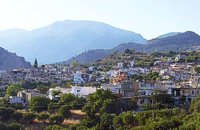 Ierapetra, Lassithi One of the largest villages of Crete, in the north of the valley of the river Sarantapichos. It is 28 km away from Ierapetra and 40 km away from Aghios Nikolaos, in a verdurous slope within immense olive groves, with an unlimited view to the valley of Myrtos, the Libyan Sea and the mountain peaks that surround it. 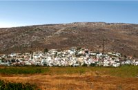 Sitia, East Crete The hilly village of Ziros (GR: Ζήρος) spreads over the lower slopes that the locals call Egremno (the Cliff) at an alti-tude of 590 m. at the pictureque Armeni-Handras plateau. The village is the seat of the Municipality of Lefki. The village was first recorded as Siros in 1577 in the Venetian Barozzi's catalogue of the villages of Sitia. In a census carried out by the P. Castrofilaka it was listed under the same name in 1583, with a population of 448. In 1928 with the first census after the union of Crete with Greece, the population was 742. Today the population of the village is approx. 742 but diminishing. The Ziros community includes the villages of Kalo Horio, Hametoulo, the coastal settlement of Xerokampos, the deserted Lamnoni and some settlements inhabited seasonally like Agrilia, Lethi, Achladias, Makri Livadi and Anargyros. The Ziros area has many antiquities from all periods, however no methodical excavations have yet occured. Ancient sited can be found at Plakospilios (roman settlement and tombs), St. John (an Archaic set-tlement), Fonias (a Minoan settlement), Stalos (Minoan tombs and settlement), Katsoulianos (Minoan tombs), Pentalitro (Minoan Acropolis), Katergari Papa Pigadi (Minoan Settlement), Anemomilia (Minoan building), Pirgales (Minoan Villa), Vrisi Hametoulou (Minoan settlement), Limnia or Palaki Mantra Hametoulou (Minoan buildings). An important peak sanctuary of the Middle Minoan period existed at the Plagia hill but now it is ruined. The Ziros area is dotted with caves and also other geological features, the most important are: the cave of Agrilia, the cave of Lygias Spilios and the cave of Voevodas. The Ziros area has also many remarkable churches to show with the most important from all the painted church of St. Paraskevi dated back to 1523. The St. Nikolaos church has graffiti dated back to 14th and 15th century. 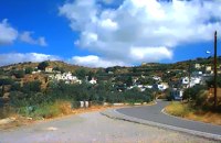 Sitia, East Crete The village of Papagianades (GR: Παπαγιαννάδες) with ~160 inhabitants, is situated in the area of Lefki at an altitude of 480 m above sea level, approximately 90 km from Agios Nikolaos and 19 from the town of Sitia. It was first recorded in an Egyptian census in 1834 with 8 Christian families. It was also recorded by Chourmouzi Byzantios in 1842. In the 1881 census the village is recorded with a population of 77 pertaining to the Community of Handras. The Ai Lias hill just before entering the village is of local interest as well as the Monastirakia, a ruined Minoan settlement. There is also the church of Panagia Eleousa with frescoes dated back to the 14th century. The sightseer can sit and relax at the marvelous Panteli, a place in a gorge with lot of trees, joining the villages of Papagianades and Maronia. The chapel of Virgin Mary is worth visiting as well. 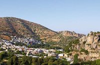 Ierapetra, Lassithi One of the most beautiful parts of the hinterland of Ierapetra is occupied by the picturesque village of Kalamafka. It is situated on the edge of the Lassithi mountains, an area known for its impressive diversity in landscape. Kalamafka sits at an altitude of 480 meters, 15 kilometers from the town of Ierapetra and 25 kilometers from Agios Nikolaos. Kalamafka is a picturesque, large, and prosperous village surrounded by unique natural beauty. The springs at Kefalovryso, with its plane trees and lush vegetation, as well as its old historical churches, gorges, and springs, attract visitors due to the oasis-like coolness it offers in this otherwise dry and hot region. The village's wealth lies in its water sources and the vitality of its residents, who resist urbanization. Another reason for Kalamafka's enduring population is its advantageous location, as it is centrally positioned between the north and south coasts of the island, drawing daily visitors from Ierapetra and Agios Nikolaos. History: The village derives its name from "Kali Afkla," a wooden channel that was once used to transfer water from one riverbank to another at the springs of Kefalovryso. Another explanation for the name is that the rock formation on Kastelos Hill resembles a Greek Orthodox priest's hat (kalymafki). Kalamafka, known as ancient Larisa, has been inhabited since the Minoan era. In the Psathi area, along the road to Ierapetra, archaeological findings such as human skulls, clay pots, spearheads, and various grave goods from the sub-Minoan era have been discovered. The geographer Strabo mentions Kalamafka, ancient Larisa, as follows: "And in Crete there is the city of Larisa, which now is united with Ierapytna, and from which the plain below, called Larision, takes its name." The god protector of ancient Larisa was Asclepius, and this is why the Medical Association of Lassithi has adopted the figure of a statuette discovered on the Kastelos peak, which overlooks the village and served as a peak sanctuary according to Mr. Michalis Pytikakis. Larisa was conquered around the 3rd century B.C. by Ierapytna, and its residents were relocated as per the terms of the treaty. Evidence from subsequent historical periods suggests that the Kalamafka area has been continuously inhabited due to the presence of the water sources of Kefalovryso. Place names like Kastelos, Mesokastela, and Larisakia attest to its historical significance. Kastelos Hill, serving as the seat of a feudal lord during the Venetian rule, had 435 residents in 1583. It boasted several notable Byzantine and post-Byzantine churches, along with numerous chapels. During the Turkish rule, it was a breeding ground for prominent chieftains like Nikolaos Foniadakis and Ioannis Baritakis. The village's history is marked by struggles and sacrifices that cannot be easily summarized. Today, Kalamafka is a vibrant village with a growing population. It has a two-seat school, a nursery school, a cultural association, numerous coffee houses, and seven taverns. The natural landscape, often referred to as "Chinese" due to its small rock pillars with bonsais, stone formations, and Kastelos Hill with its 224 steps, is considered a monument of natural history. Kalamafka offers visitors a wealth of attractions, including caves, rock paintings, the Havgas gorge, an ancient olive press, and the churches of Saint John and Saint Anthony. The taverns, shaded by plane trees and surrounded by running water, serve traditional and delicious local dishes, including the traditional "klostenios" halva and skyfomakarounes (local pasta). The sounds of the lyra, violin, and lute add to the ambiance, pleasing both locals and foreigners. There are indeed many compelling reasons to visit Kalamafka. By Toby Robert Image Library
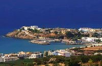
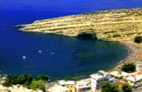 Messara, South - West Iraklion Matala (GR: Μάταλα) was the ancient port of Phaistos and Gortys and a former fishing community which has developed into a modern holiday center. It is located 4 km south-west of the village of Pitsidia and 75 km from Iraklion. It is built on the coast line of the Messara bay inside a small and picturesque inlet. During the 60's the caves of Matala were hosting a hippie commune.
 Mirabello, Lassithi The village of Sissi, a picturesque village 40 km east of Heraklion and 25 km west of Ag. Nikolaos. Sissi is a beautiful fishing village with strange nature. On one side of the village the nature is wild, with a small river flowing into the sea, a number of palm trees on its banks, ducks and geese swimming peacefully. On the other side there are sandy and gravel beaches, caverns in the rocks and deep clear water, full of many kinds of fish. A place that gathers the nature of different places of Crete.
 Sfakia, White Mountains It is located at an altitude of 750 m, 50 km SE from the city of Hania and 20 km from the village of Vryses. Its population is approximately 500 people. The small villages that constitute the community of Askifou are Kares, Ammoudari, Goni and Petres. The most touristic organised of them is Ammoudari with restaurants, gas station, and some rooms for rent.
 Rethymnon North A beautiful small town in the county of Rethymno with great views, natural water springs and lush vegetation. It's located at 260m a.s.l. between the rivers "Mousselas" and "Petres", 22km from the national road and 5km from Episkopi. Argiroupolis is the site of the ancient city of Lapa.
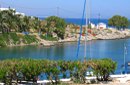
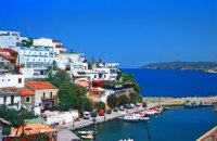 Rethymnon North coast Bali is a small fishing village, about 40 km west of Iraklion and 37km east of Rethymno easily accessed from the international road. It has a small picturesque harbour and lots of small coves with wonderful clear beaches. Recent years Bali has been developed to a popular tourist resort but it is still preserves its traditional character. Ideal place for family holidays, with small hotels and lovely taverns serving fresh fish and local specialties. 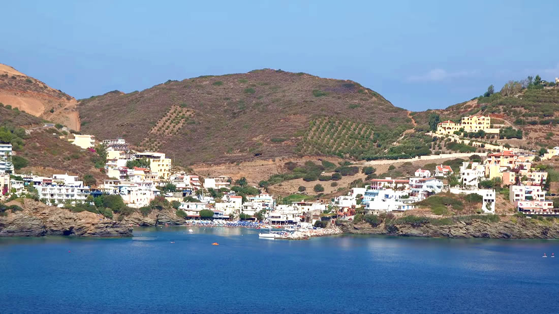 The Venetians called the place "Atali", from its ancient name which was "Astali", while its current name was given by the Ottomans. There is also the Atali Monastery nearby, which retains the medieval name of the place and is dedicated to Saint John. The monastery is built on a small elevated peninsula overlooking the bay and the Cretan sea. Image Library
 Messara, Iraklion South Gallia is one of the oldest villages of the area. It is mentioned as a location in the Venetian records as early as 1577, and as a village with 120 residents since 1583. The renaissance tower in the village (still imposing although rundown) and the water fountains in the Kapeloniana area are proof of the passing of the Venetians. Part of the village, called Monohoro, is mentioned as early as 800 A.D. |
||
|
| ||


)
)
)
)
)
)
C
O
N
T
E
N
T
S
O
N
T
E
N
T
S