interkriti®
YOUR GATEWAY TO CRETE
HOME
CRETE FACTS
NAVIGATE
EXPLORE

Agia Galini
Triopetra
Kissamos
Chryssi Isl.
Agia Marina
Balos
Gavdos isl.
Georgioupolis
SAMARIA
IDA Mtn
Palaiochora
Agia Roumeli
Sfakaki
Bali
Kalamaki
Matala
Lassithi
Plateau Lendas
Tsoutsouros
Vianos
Myrtos
Sfakia
Plakias
Ierapetra
Makrygialos
ZAKROS
Vai
Sitia
Agios Nikolaos
Elounda
MALIA
Hersonissos
Gouves
Chania
Rethymnon
Heraklion
GORTYN
FESTOS
KNOSSOS
|
|
Crete
: Towns & Villages
List Grid Map
Found
38
- Showing :
21 - 38
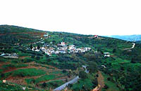
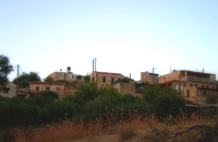
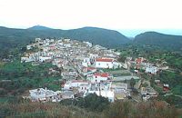
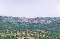 Kenourgiou, Iraklion at 20.6km (S) Moúlia (GR: Μούλια) is a village in Kenouriou county, located three and a half kilometers away from Agia Varvara town and 32 km from Iraklion at an altitude of 640 m above sea level. Moulia is an old village as we come across a reference to it in a document dated in 1248, where the settlement is recorded as belonging to the archbishopric of Crete. Another reference is found in a legal agreement established in 1411. The name figures in all the Venetian censi of the 16th and 17th centuries, as well as in the Turkish and Egyptian censi. In 1881, it forms part of the municipality of Zaros with about 180 inhabitants, and again in 1900. As of 1920 it is a commune in its own right, and today with the lower village of Kato Moulia it counts over 550 inhabitants. The main church of the village, with wall paintings, is that of the patron saints, Saints Peter and Paul, and there is a village feast on the 29th June, in their honour. The lovely chapel of Zoodochos Pigis is also well worth a visit.
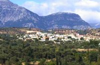
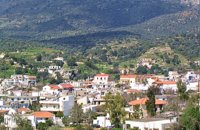 Kenouriou, South Iraklion at 21.3km (SW) Zaros (Greek: Ζαρός), at an altitude of 340 metres, is a town with a lake and gorge nearby. It has a couple of hotels and it is 44 km from Heraklion at the southern foothills of Mountain Psiloritis. The population of 3,400, produce olive oil, sultanas, vegetables and spring water. There are a couple of fish farms that serve both trout and salmon. In Zaros, there are cafes near Lake Votomos, as well as a tavern that serves fresh trout called I Limni (The Lake). Close by is Rouvas Gorge, which is part of the Psiloritis mountain range and is on the hiking route known as the E4 European Walking Path. Nearby Zaros are traditional water mills which have been working since the 16th century, as well as archaeological sites and monasteries. Zaros is also famous for its water "ZAROS" bottled by a company called Votomos SA.  Rethymnon North coast at 25km (NW) Bali is a small fishing village, about 40 km west of Iraklion and 37km east of Rethymno easily accessed from the international road. It has a small picturesque harbour and lots of small coves with wonderful clear beaches. Recent years Bali has been developed to a popular tourist resort but it is still preserves its traditional character. Ideal place for family holidays, with small hotels and lovely taverns serving fresh fish and local specialties.  The Venetians called the place "Atali", from its ancient name which was "Astali", while its current name was given by the Ottomans. There is also the Atali Monastery nearby, which retains the medieval name of the place and is dedicated to Saint John. The monastery is built on a small elevated peninsula overlooking the bay and the Cretan sea. Image Library
 Gouves, Iraklion at 25.3km (E) Vorou (or Voritsi) lies at a height of 230 m. above sea-level and counted 62 inhabitants in 1981 and 48 in 2001. It is 25 kms away from Heraklion. To get there, you follow the National Road to Aghios Nikolaos and at kms 17.7 turn right, taking the road Gouves-Skotino- Vorou. Nowadays it is known as Voritsi but this name is not official. The name Vorou, on the other hand, in the district of Pediados is mentioned by Barozzi in 1577. At the beginning of this century there lived a wise man and a healer in the village of Voritsi. His name was Giorgos Konstantoulakis and people flocked from all over to Crete to seek his advice.
 Gouves, Iraklion at 26km (E) At a height of 140m. above sea-level, this village has 142 inhabitants and is 22.5 kms away from Iraklion. According to the villagers, the name comes from the church of Aghios Nikolaos Skotino at the entrance of a cave. It was built at the end of the Venetian period. Today an extra wing has been added, dedicated to Aghios Charalambos. This church of Aghios Nikolaos Skotino presumably functioned as a "Hedge School" (or "Hidden School") under Turkish rule when education had been banned. When the locals said: "We are going to Skotino (which also means "darkness")", they meant they were going to school. Turkish administration refers to this place as Skotino Perasma in 1671. Very close to the village (1.5 km) the cave of Aghia Paraskevi draws crowds of tourists and is well worth a visit.  Gouves Beach, North - East Iraklion at 26.2km (E) Káto Goúves (GR: Κάτω Γούβες or simply Gouves) is a modern tourist resort with a complete tourist infrastructure to meet all demands. Organised beaches, large modern hotels, family apartments, restaurants, small tavernas, recreation centres, sports centre, shops, car and motorbikes for rent, small ports (marinas) for small boats, in a word Kato Gouves provides everything the visitors require to spend an agreeable and carefree holiday, enjoying the sunshine by day and the thrilling night-life in the numerous bars in the area. Just a few kilometers inland there are picturesque traditional villages, historic monasteries, caves and other natural beauties. Image Library
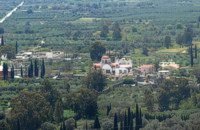
 Gouves, Iraklion at 26.5km (E) Pano Gouves (GR: Πάνω Γούβες) is a village of the district of Pediada in the prefecture of Iraklion at a height of 100 metres above sea-level. It lies twenty kms away from Iraklion, to the right at 17.3 kms on the National Road to Aghios Nikolaos. The village is built on the western flanks of the Ederi hill (322 m.). The name comes from "edera" which means ivy and symbolises affection. The name Gouves, on the other hand, comes from Gouva and means a hollow in the earth. It also means, in Crete, a hole in which during the middle ages, people stored their wheat. The earliest reference we have of the village is that of "Guves" in 1387 documents of the Duke’s archives in Chandax. Later on, in 1577, Fr. Barozzi mentions "Guvos" in the district of Pediados, and then "Guves" in the 1583 Register, with 252 inhabitants. Finally, in 1630, Vassilikata refers to "Vuves’. This is the birthplace of the poet Ioannis Konstantinidis. There are several outstanding churches in the village, among them: Zoodochos Pigis, Aghios Giorgos, Aghios Ioannis and Panayia (dedicated to the birth of Our Lady). 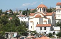 Pediada, Iraklion at 26.6km (E) Apostoloi (GR: Αποστόλοι) is a village in the area of Kasteli, 360 m above sea level. It has about 490 inhabitants, and is located on the 32 km of the road leading to Kasteli in the NW part of Apostolianos Kampos, among vineyards and olive groves. Until recently tannery was a main activity among the villagers. The earliest reference to the name is to be found in a contract drawn in 1279, where Sancti Apostoli et Sophoro were lands belonging to the Venetian lord Leonardus Gradonicus, who gave them and leased them to Petro Quinino. There is another mention of the name in a document dated to 1378. It is also quoted by Fr. Barozzi in 1577 as forming part of the Pediada district. The name of the village finds its origins in the name of an old church dedicated to the Saint Apostles. The present church was built on the same site in the 19th century, in 1876. The church of Agios Giorgos is Byzantine and has wall paintings. According to village tradition, on the night of Easter in 1841, the Turks caught the Cretan leader of the revolution for the Eastern part of the island, Giorgos Vassilakis, or Vassilakogiorgi and hanged him from a fig tree.The village kapheneions serve particularly good raki and on June 29th there is a great feast in the honour of the Saint Apostles, Peter and Paul. 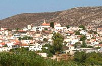 Pediada, Iraklion at 26.6km (E) The village of Smári (GR: Σμάρι) is a traditional Cretan village, only 10 km away from Kasteli and has 375 inhabitants. In it you will find beautiful old stone houses that have been restored, picturesque little alleys, ruins of older buildings and pottery workshops where you can purchase copies of Byzantine and Minoan ceramics. There are also some interesting churches with wonderful frescoes like the one dedicated to Sotir Christos, the Koimisi tis Panagias and Agios Giorgos. The earliest reference to the village of Smari dates back to 1375. There is a lively Cretan feast on July 20th in honour of Profitis Ilias, with much rejoicing, singing and dancing.  Messara, Iraklion South at 27.2km (S) Agioi Déka (GR: Αγιοι Δέκα) is a town with 820 inhabitants in the plain of Messara, 170m above sea level, 43 km from Heraklion town and very close to the archaeological site of Gortyna. Its people are occupied mostly in agriculture - vines and olive trees. In the area there is is the oldest olive grove in Crete. The town is built on the ruins of the ancient town of Gortyn where the Holy Ten Martyrs have been martyred. 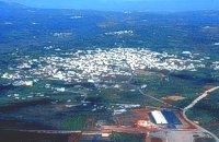 Central Iraklion at 27.6km (SE) The town of Arkalochori (GR: Αρκαλοχώρι) with a population of 2.881 is located 33km away from Heraklion, on the provincial road linking Heraklion and Viannos, at 395m above sea level. Its inhabitants are mostly involved in agriculture, but in commerce and arts as well. Arkalochori is one of the most developing towns in the prefecture of Iraklion both in economic and cultural sectors and is the administrative center of the area. Events such as the Pancretan Agricultural and Commercial Exhibition, that takes place here are of great significance and interest for the whole island. The town offers a full range of modern facilities to its residents and visitors.
Image Library
 Mires, Messara Valley at 28km (SW) It is located north of Mires close to a small gorge, with springs and covered with trees. There are many churches in the village the most important one being the church of Agios Nikolaos, a domed church dated to the 13th century. The walls of the temple are hand painted with biblical scenes and pictures of saints
 Village in Messara plain at 28km (S) Mitropoli (GR: Μητρόπολη) is a small village in the archaeological site of Gortyna in Messara plain. The village is mentioned for the first time in the Ducal archives of Candia in 1368 and later in the census of 1577 by Fr. Barozzi and in 1583 by Castrofylaka. Early mention of the settlement is to document the Ducal Archive of Candia in 1368, also mentioned by Fr. Barozzi in 1577 with the name and the Mitropoli Kastrofilakas in 1583. According to the census of 2001 it has 382 inhabitants. Main occupations of the inhabitants is the cultivation of vines, olives, vegetables, cereals and citrus fruits. At its north borders are located the ruins of the first cathedral of St. Titus, in which it owes its name.(Mitropoli = Cathedral). Image Library
 Messara, Iraklion South at 28.2km (SW) Gallia is one of the oldest villages of the area. It is mentioned as a location in the Venetian records as early as 1577, and as a village with 120 residents since 1583. The renaissance tower in the village (still imposing although rundown) and the water fountains in the Kapeloniana area are proof of the passing of the Venetians. Part of the village, called Monohoro, is mentioned as early as 800 A.D. 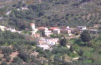 Pediada, Iraklion at 29km (E) To the east of Smari, at 400 m above sea level, with 99 inhabitants, Lagou (GR: Λαγού) is first mentioned in the Turkish census of 1671 with 4 haratsia (head tax). The journey to the village is charming getting you through areas of impressive wild landscape, and the typical old stone houses of Lagou, through the combined efforts of the members of the cultural centre, are being restored to their original traditional form so as to get the well deserved honour of being considered a protected traditional settlement. Image Library
 Gouves, Iraklion at 29km (E) At a height of 320 m above sea-level, Kalo Chorio (GR: Καλό Χωριό) λιεσ 25.7 kms. from Heraklion, to the right at the cross-roads at km 16.7 on the National Road to Agios Nikolaos and on the road to Gouves- Koxare- Kalo Chorio. The present name does not figure in old Venetian documents, though there is a reference in the 1367 Duke’s archives of Chandax to a Kalo Horio, without however naming the district. The villagers maintain that the village was called Stravorina in the old days, and indeed there is a reference by Barozzi in 1577 to a village Stravorina in the district of Pediados. In the 1583 Register, the village Stravorina is mentioned as having 76 inhabitants and in the Turkish census of 1671 Istavrine is quoted as having 21 "charatsa" (A Turkish word referring to a tax paid by the head of each family; hence 21 families). However, Chourmouzis Vizantios in 1842 mentions Kalo Chorio, the present name was therefore given in the decade 1830-1840. The village counted 298 inhabitants in 1981 which is also the current population. The Maza hill-top, south-east of the village, is 457 metres high. According to archaeologists (among them the famous N. Platon) and on the basis of recent finds, the name Maza comes from pre-Hellenic years and means Mother Earth. The pile of stones on the hill was, according to N.Platon, a town from the 10th to the 8th c. BC. The highest part was undoubtedly used as a shrine in Middle-Minoan years, and clay figurines and offerings were found there. The shrine lay quite close to the town. The shrine stopped being used in Proto-Geometric years. Northeast of the village, by the country road that leads from Kasteli to Hersonissos, traces of ancient installations have also been found along with remnants of water tanks by a source that is still in use today. These water tanks, probably belonged to Hersonissos aqueduct, parts of which are still visible today in Aposelemi valley. There is as well an interesting gorge close to Kalo Chorio, in the valley of Aposselemis river, worth seeing for nature lovers. 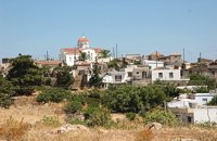 Pediada, Iraklion at 29.1km (SE) Evangelismos (GR: Ευαγγελισμός) at 360 m above sea level, with 365 inhabitants, lies to the SW of Kasteli, distant only 5 km from the county town and about 35 km from Heraklion. In earlier years, the village was called Mouktari or Mouchtari and its name figures in a 1381 contract for the buying and selling of grain. The Byzantine church of the Panagia is worth a visit. On August 6th the village celebrates the feast of the Metamorphosis. Evangelismos is the seat of the newly (2010) created municipality, according to the National "Kallikratis Project", by uniting the former municipalities of Kastelli, Thrapsano and Akalochori. The name of the new municipality is "Minoa Pediada" 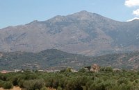 Pediada, Iraklion at 29.4km (E) 330 m above sea level, just out of Kasteli (1.5 km) to the east, lies the village of Archangelos (GR: Αρχάγγελος) with 433 residents. It was founded in 961 by the military forces of Nikiphoros Phocas and was originally named ‘Varvaro’, and was still known by that name in 1583, where the Chandax Register puts it down as a village of the Pediada district with 37 inhabitants. Its name was changed only recently, in 1961, to Archangelos, and the main village church in the square is dedicated to the Archangel Michael. There is another smaller and older church, that of the Panaghia, with Byzantine wall paintings. Remains of ancient mills can still be seen. In a location known as Trochalos, archaeological finds have brought to light a series of Minoan tools dating back to the first and second Late Minoan periods. As in every Cretan village, raki and ‘mezedes’ are always available at the kapheneions. The feast of Michail Archangelos on November 8th is celebrated with much feasting in the village. |
||
|
| ||


)
';top.fotoWin('/dbsf/pages_pics/15/1522205/aposselemi_gorge01.jpg','');)
C
O
N
T
E
N
T
S
O
N
T
E
N
T
S