interkriti®
YOUR GATEWAY TO CRETE
HOME
CRETE FACTS
NAVIGATE
EXPLORE

Agia Galini
Triopetra
Kissamos
Chryssi Isl.
Agia Marina
Balos
Gavdos isl.
Georgioupolis
SAMARIA
IDA Mtn
Palaiochora
Agia Roumeli
Sfakaki
Bali
Kalamaki
Matala
Lassithi
Plateau Lendas
Tsoutsouros
Vianos
Myrtos
Sfakia
Plakias
Ierapetra
Makrygialos
ZAKROS
Vai
Sitia
Agios Nikolaos
Elounda
MALIA
Hersonissos
Gouves
Chania
Rethymnon
Heraklion
GORTYN
FESTOS
KNOSSOS
|
|
Crete
List Grid Map
Found
164
- Showing :
41 - 60
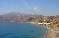 Monofatsi, South Iraklion at 17km (S) Tsoutsouros (GR: Τσούτσουρος) is a small village on the southern coast of Iraklion prefecture, with lovely beaches and a small harbour. The ancient city of Inatos, used to stand were Tsoutsouros is now. Inatos served as a port to Priansos a renowned city - state of the Hellenistic time, located near the village of Kasteliana. Tsoutsouros is a popular tourist resort especially with Greek families. There are many taverns and cafes most of them around the small harbour, and a good choice of apartments and hotels along the beach. Image Library
 Krassas, Tsoutsouros at 17.1km (S) Palm House is a beautiful stone-built house on the south coast of Ceete. It is built on a tree-lined plot with panoramic sea views ,ideal for comfortable accommodation for 4 people. Its distance from the sea is only 300 meters.
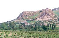
 Krasas, Tsoutsouros at 17.3km (S) Seaside Houses located an hour drive (60kms) from Heraklion's airport at Tsoutsouros village. The houses are on the top of a headland separating two bays with magnificent beaches - the one almost private! - constituting a majestic scenery of virgin Crete with both sea and mountain view. Unique place for those who seek privacy, peace and romantic mood. The houses are fully equipped and have large shaded verandas. Prices from € 160/ night (2people)  Archanes at 17.4km (NW) Anemóspilia (GR: Aνεμόσπηλια). Anemospilia is an archeological site at the northern foot of Mount Yuchtas, in the prefecture of Heraklion in Crete. A rectangular building has been found which dates from the Minoan era and was destroyed by an earthquake in the 17th century BC. The building with three narrow chambers, each opening into a long corridor to the north, which extends along the whole width of the building. The area is enclosed with a stone wall and the whole structure has been interpreted as a shrine; in the central room was found a "xoanon" (statue) of the deity worshiped here. In the west room, where the altar stood, was uncovered, according to the excavator, the first human sacrifice to have ever taken place in Minoan times. (although this view has been challenged). The building at Anemospelia was used for only half a century, as it was suddenly destroyed by an earthquake in the middle of the 17th century B.C. The site was excavated in the summer of 1979 by John Sakellarakis. 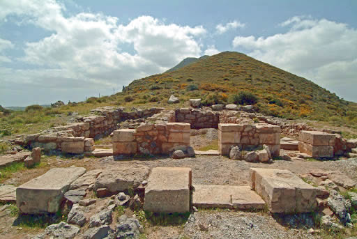 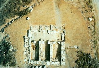 Aerial view 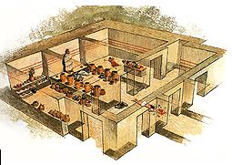 Shrine model Links: Minoan Religion (Foundation of the Hellenic World)  Iraklion at 17.4km (NW) The town of Profitis Ilias (GR: Προφήτης Ηλίας), or Roka for the locals, is found 20km south of Heraklion It is built on the top of two hills offering an unforgettable view to the surrounding areas. A natural fortification, due to its position, it has been suggested that ancient Lycastos was built here. It is also known as Kandli Kasteli due to the castle located at the summit of a rock southeast of the town. Nikiforos Fokas built the Byzantine castle of Temenos in the same location in 961 when he freed the island from the Saracens. His objective was to bring the city of Hantaka (Heraklion) into the castle of Temenos. However, this did not materialize and the city remained were it was. In the thirteenth century the castle of Temenos was occupied by the Genoese Pescatore, and later by the Venetians. The name Kanli Kastelli in Turkish means blood-painted castle, and took its name from a massacre of Turks by the Venetians and Greeks that took place here in 1647.  by Richard Ellis at 17.9km (W) 10th June- I packed up the tent early after a noisy night of competing dogs and was on the road by 0615. After 3 or 4 kilometres on a mix of dirt roads and tarmac roads, I managed to find the concrete road which is the official E4 (marked with paint on a concrete watertank) up from Pirgos and a couple of hours later I was in Venerato having a frappe in the café by the turn to Kerasia.. Distance:35.8km Time: 13.75 hrs. Mov av 3.9 km/hr Height overnight: 945m. Max. height: 1600m 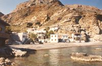 Monofatsi, South Iraklion at 18km (S) Maridaki (GR: Μαριδάκι) is a small coastal hamlet in the bay of Tsoutsouros on the southern coast of Iraklion prefecture. It is built at the end of the gorge of Ahendrias.
Image Library
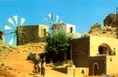 Seli Ampelou, Lassithi Plateau at 18km (NE) It is the most significant group of windmills preserved on Crete. It occupies the northern entrance to the Lasithi plateau and is the landmark of the whole area. Today 24 windmills are preserved (out of the original 26), 7 of which extend to the south of the road that enters the plateau while the rest are built to the north of it. All the mills belong to the one-sided type of windmill, that grinds in a standard position, always on the same direction of the wind. Windmills of this type are preserved on Crete and on Carpathos but the Cretan ones are generally more carefully built and more elegant. The group of windmills has been declared a work of art since 1986. The mills belong to individuals and some of them have been restored while others still remain half-ruined. Source: The Hellenic Ministry of Culture  Gouves, Iraklion at 18km (N) At a height of 140m. above sea-level, this village has 142 inhabitants and is 22.5 kms away from Iraklion. According to the villagers, the name comes from the church of Aghios Nikolaos Skotino at the entrance of a cave. It was built at the end of the Venetian period. Today an extra wing has been added, dedicated to Aghios Charalambos. This church of Aghios Nikolaos Skotino presumably functioned as a "Hedge School" (or "Hidden School") under Turkish rule when education had been banned. When the locals said: "We are going to Skotino (which also means "darkness")", they meant they were going to school. Turkish administration refers to this place as Skotino Perasma in 1671. Very close to the village (1.5 km) the cave of Aghia Paraskevi draws crowds of tourists and is well worth a visit. The Crete Golf Club Hersonissos, Pediada at 18.4km (NE) 18 holes in a desert course design. Each hole individually sculptured, seamlessly blending into the existing landscape...The new Bob Hunt masterpiece (head of design at the PGA Golf Management Ltd of Great Britain), is best described as a desert golf course hewn out of rolling landscape little more than half an hour from the international airport of Heraklion. It boasts a series of memorable holes that will test every aspect of a golfer's repertoire and offers stunning views over mountainous landscape that has hardly changed since the Minoan era back in 2600 to 1100 BC.  Lassithi, Dikti Mountains at 18.5km (E) The Lassithi Plateau (GR: Οροπέδιο Λασιθίου, Oropedio Lasithiou), is a high endorheic plateau, located in eastern Crete, Greece on the mountain range of Dikti at an average altitude of 840 m, and in a distance of around 55km from Heraklion and 50km from Agios Nikolaos. The plateau is elliptical in shape with an E-W axis of 11km and the N-S of 7km. The plateau of Lassithi is renowned for its exceptional agricultural produce, the thousands (almost 15000) windmills that used to be there in the past, its significant historical role and for the unique cave of Psychro also known as "Diktaion Andron". Image Library
 Skotino,Gouves, Iraklion at 18.6km (N) This is one of the three largest caves in the prefecture of Heraklion. It lies at half an hour distance to the north-west from the village of Skotino and is at a height of 225 m. above sea-level. The entrance to the cave is impressive: a large arch, 27 m wide and 10 m high. To the right one can see the ruins of an ancient chapel on which the modern chapel dedicated to Aghia Paraskevi was built. There is a feast held in front of the chapel on July 26th .
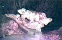
 Kenouriou, Iraklion at 18.9km (W) Doúli (GR: Δούλι) is a village in Kenouriou county, located 38 km from Iraklion at an altitude of 440 m above sea level. The earliest reference to it, is to be found in the Duke's Archives of 1372, where it is mentioned as the feudal property of Nic. Venerio. The name figures in all the Venetian censi of the 16th and 17th centuries, as well as in the Turkish (1671) and Egyptian (1834) censi. In 1881, Douli forms part of the municipality of Megali Vrisi with about 170 inhabitants, and again in 1900 with only 21 inhabitants. As of 1920, Douli is a commune in its own right, and today Douli has about 240 residents. The patron saint of the village is Aghios Panteleimonas and the feast of the Saint is celebrated on July 27th.A visit to the old church of Aghios Nikolaos is also a must. For those interested in paleontology, there are fossils to be found at the location 'Pirgos'.  by Richard Ellis at 19.2km (E) This was another delightful start to a day’s walking. Rather than tramping round the perimeter which is more or less where the E4 is supposed to go, it is quite possible to take a diagonal line from the south east corner to the north west corner by taking a right, then a left, then a right etc so you end up close to Kato Metochi. This way, you get to see close up the extent of the agricultural activity going on around the plateau in the morning sunshine. You also get to see the newly formed baby frogs – fresh from tadpole status – hopping happily in the sunshine in front of my big boots. Distance: 23.5 km Time: 7 hrs. Mov av 4.7 km/hr Height overnight: 335m.(max 824m.)  Gouves, Iraklion at 19.5km (N) Pano Gouves (GR: Πάνω Γούβες) is a village of the district of Pediada in the prefecture of Iraklion at a height of 100 metres above sea-level. It lies twenty kms away from Iraklion, to the right at 17.3 kms on the National Road to Aghios Nikolaos. The village is built on the western flanks of the Ederi hill (322 m.). The name comes from "edera" which means ivy and symbolises affection. The name Gouves, on the other hand, comes from Gouva and means a hollow in the earth. It also means, in Crete, a hole in which during the middle ages, people stored their wheat. The earliest reference we have of the village is that of "Guves" in 1387 documents of the Duke’s archives in Chandax. Later on, in 1577, Fr. Barozzi mentions "Guvos" in the district of Pediados, and then "Guves" in the 1583 Register, with 252 inhabitants. Finally, in 1630, Vassilikata refers to "Vuves’. This is the birthplace of the poet Ioannis Konstantinidis. There are several outstanding churches in the village, among them: Zoodochos Pigis, Aghios Giorgos, Aghios Ioannis and Panayia (dedicated to the birth of Our Lady). 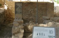 Knossos Palace at 20.2km (S) This room lies at the southern part of east wing in an area with many small rooms (possibly storerooms and magazines), lustral basins and light-wells. It was made into a shrine at the end of the Postpalatial period (1375-1200 B.C.). It is known as the "Shrine of the Double Axes". On a bench at the back, different ritual objects were found amongst which were a stone double axe and votive clay idols - among them the terracotta figurine of a goddess with upraised arms. Similar small shrines have been found in houses of the same period.
Image Library
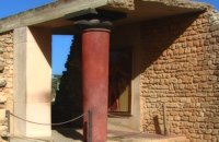
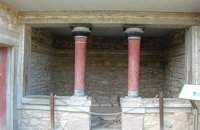 Knossos Palace at 20.2km (S) This house belongs to the New Palace Period (1700-1450 B.C.) and was functionally related to the Palace. In its restored part with two columns, there was a bench on which some object of worship had probably been set up. There was a paved hall in front with a double pier - and - door partition.
Image Library
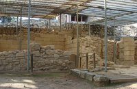 Knossos Palace at 20.2km (S) The south-east house belongs to the New Palace period (1700-1450 B.C.). It was well built and decorated with wall-paintings of lillies. It had a pier-and-door partition, a pillar room and storage rooms. A little behind it are other houses of the Old Palace period (1900-1700 B.C.) such as the house of the "Sacrificed Oxen", named after the remains of a sacrifice found there (horns of a bull and a tripod table of offerings) and the "House of the Fallen Blocks", after the blocks that had fallen from the facade of the palace due to an earthquake. Next to "South-East House" there are houses of the Old Palace period (1900-1700 B.C.), such as that of the "Monolithic Pillars" in front of the steps. Under the small roof is a Minoan, possibly smelting kiln. 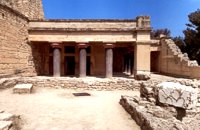 Knossos Palace at 20.2km (S) The "Hall of the Double Axes" was so named by Evans due to the double axe signs engraved on the walls of the light-well at its rear. He also thought that it was the place of residence of the King of Knossos. The central area has openings on three sides and is therefore called a "polythyron" (system with multiple doorways). It has a slab floor and its walls were embellished with gypsum slabs and frescoes. The area between the "polythyron" and the light-well was used as a reception hall. Traces of a wooden construction were found here. Evans reconstructed a wooden throne at this spot. Pictures: 1, 2 According to the archaeological finds, the arrangement of the apartments on the upper floor was similar to those on the ground floor. Image Library
 Palace and Archaeological site at 20.3km (NW) The famous Palace of king Minos and the centre of the Minoan civilisation 5km south of Iraklion. The Great Palace covered an area of 20.000 sq. meters and had 1.400 rooms. Every section of the Palace had a specific use. In the west side of the Palace were the chambers of the ceremonies, of the administration and of the public storehouse...
Image Library
|
||
|
| ||

;)
;)
C
O
N
T
E
N
T
S
O
N
T
E
N
T
S