interkriti®
YOUR GATEWAY TO CRETE
HOME
CRETE FACTS
NAVIGATE
EXPLORE

Agia Galini
Triopetra
Kissamos
Chryssi Isl.
Agia Marina
Balos
Gavdos isl.
Georgioupolis
SAMARIA
IDA Mtn
Palaiochora
Agia Roumeli
Sfakaki
Bali
Kalamaki
Matala
Lassithi
Plateau Lendas
Tsoutsouros
Vianos
Myrtos
Sfakia
Plakias
Ierapetra
Makrygialos
ZAKROS
Vai
Sitia
Agios Nikolaos
Elounda
MALIA
Hersonissos
Gouves
Chania
Rethymnon
Heraklion
GORTYN
FESTOS
KNOSSOS
|
|
Crete
List Grid Map
Found
84
- Showing :
41 - 60
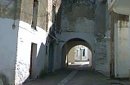
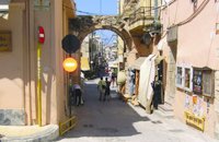 Rethymnon Old Town at 18.3km (E) The Guora Gate (Porta Guora or Grand Gate)) is the main entrance of the Venetian city walls that protected the city of Rethymno. The gate was built in the years of Rector Rettore Jocopo Guoro (1566-1568). Part of the gate is preserved at the beginning of the street "Ethnikis Antistaseos". It is 2,60 m. wide, built with carved stones with skew acnes, creating a semicircular arc on the top. According to traveler J. Gerola, the initial shape of the gate was formed by stepped cornice and pediment where a relief the lion of St. Marcos (the Venetian emblem) existed. Today the relief is preserved in two pieces and is stored at Loggia's courtyard. Old drawings of Guora Gate: inside the walls - outside the walls Image Library
 Rethymnon Old Town at 18.3km (E) The Museum of Submarine Life is situated at Arapatzoglou street, at the center of Rethymno's old city. It was founded by the "Moshaki" family, in memory of their lost child, who drowned in the sea. The largest part of the exhibits are made up of shells, while a few vertebrates, sponges and fish are also on display.
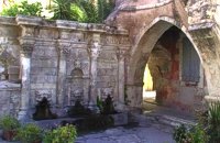 Rethymnon Old Town at 18.4km (E) A. Rimondi, the Rector of the city, built the famous Rimondi Fountain, which is situated at present day Platanos Square, formerly the centre of Venetian city life, in 1626. The water runs from three spouts in the shape of a lion's head into three sinks. Three small, fluted columns, ornamented with Corinthian capitals are "standing" on the sinks. Above the capitals an entablature can be observed, the middle part of which displays four projections in the shape of the leaves of the acanthus exactly above the columns. Furthermore in this section the words LIBERALITATIS and FONTES are inscribed.
Image Library
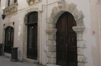
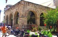 Rethymnon Old Town at 18.5km (E) Loggia has been built during the 16th century and was designed by the famous architect Michel Sanmicheli. Loggia was an eminent building of the city centre and has been a meeting point for the nobles to discuss political and economical issues. The building is very well preserved; it is square and has arches on its three sides (besides its west side). The consoles of its eaves are spectacular. During the Turkish occupation the loggia became a mosque and a minaret was constructed, which was later demolished in 1930. The past 40 decades the building of Loggia hosted the archaeological museum of the city, which has now moved to a building next to Fortezza. Today loggia hosts a market of archaeological art copies.
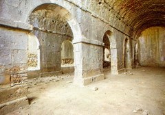
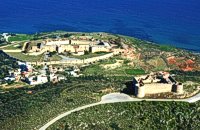 Aptera, Apokoronas, Hania at 18.6km (NW) Those are two Turkish castles that are built in the 19th century using material from the nearby archaeological site of Aptera. The lower castle is that of Itzedin (also known as Kalami fort) named in honour of the son of the Sultan of the time, by the commander of Crete, Reouf Pasha was used in the past as a prison.
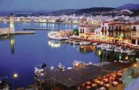 Rethymnon town at 18.6km (E) Rethymnon old port was of great strategic importance during the Venetian period. It was only able to accommodate small ships. From 1300 until today, the Venetian port has undergone numerous constructions. The 1618 wall that surrounds the port from the east is restored today with some recent interventions and additions. The original lighthouse was constructed during the Turkish period and was later replaced by another one. The building on the southeast part of the port was constructed in 1931 and functioned as a customs office. On the same location it is estimated that there was a quarantine house during the Venetian period. The vaulted spaces on the two or three-floor buildings at the port have been transformed to little and picturesque fish taverns, where visitors can enjoy the secrets of the Cretan cuisine.
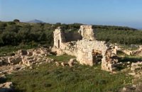 Aptera, Apokoronas, Hania at 18.7km (NW) One of the most important city - states of Crete. The first epigraphic occurence of its name (A-pa-ta-wa) is found in the Linear B tablets found at Knossos. (14th - 13th century B.C.). The history of the city is continued through the centuries untill the 7th century A.D. when a major earthquake destoyed it. Its ideal location, allowed the city to control the naval activity in the bay of Souda, and was determinative for its development in an important commercial center. The era of the city's greatest peak was the early Hellenistic period (late 4th - 3rd century B.C.). At that time Aptera experienced an economical and political floruit, begins to mint its own coins and develops diplomatic relations with important centres of the Hellenistic world.
The most important monuments of the site are: Roman cisterns. Bipartite temple, known as the "bipartite sanctuary", dated to the 5th-4th century B.C. Graves of the Geometric-Roman periods. The fortification wall, preserved to a length of almost 4 kilometres. Part of a Roman bouleuterion. Byzantine buildings. Monastery of Agios Ioannis Theologos. Turkish fortress built in 1866-1869. Source: The Hellenic Ministry of Culture 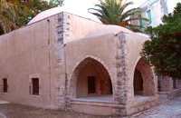 Rethymnon Old Town at 18.7km (E) The Mosque took its name from the Turkish commander of the marine operations to conquer Rethymno, in 1646. During the Venetian Period, the Mosque became a monastery dedicated to St. Barbara. West from the central building, there is the deserted minaret of the mosque. The fountain of the Mosque is attached to the roofed entrance of the Mosque's garden, where believers washed before entering the Mosque and provided the area with fresh spring water. Image Library
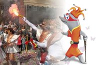 Rethymnon city at 18.7km (E) In winter the town of Rethymno lives in the rhythm of Carnival. Here, the grandest carnival on the island of Crete is organised. Apart from the great parade on Shrove Sunday, a large number of activities complete the framework of the Carnival festivities. The locals devotedly and cheerfully prepare for this season with creativity, they sacrifice their spare time and become young again while rejoicing and celebrating parties almost on a daily basis. More than 4,000 people have worked feverishly for months in order to present their masks and carriages on the great Carnival parade…The following day, on Shrove Monday people from the countryside play a leading part in the festivities. Unique traditions are revived in the villages and everybody is invited to participate in games, street performances and satires as for example “the kidnapping of the bride”, the “Cadi”, the “smudging of people”. These performances in combination with good wine and the music of the lyre are a successful formula for a unique experience. Links: www.carnivalrethymno.com 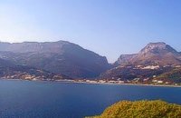 Agios Vassilios, Rethymno (South) at 19.2km (SE) A sea side village, 40 km south from Rethimno, with 237 permanent residents, built at the cove of the bay of the same name on a wonderful sandy beach, 1300 m long, between the capes Stavros and Kako Mouri, that is ideal for swimming and sea sports. The natural beauty of the place helped Plakias to become a renowned tourist resort now providing all the facilities that a visitor could wish. It belongs to the municipality of Finikas.
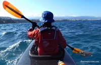 article by Stelios Asmargianakis at 19.3km (NW) An article where Stelios Asmargianakis describes his experience of sea kayak, through a two-day trip to the north of Chania as it took place in mid February 2012. The whole journey is about 40 km, and is characterized by the absence of beaches for easy approaching and relaxing as well as exposure to the elements of the Cretan Sea.
 Sfakia at 19.4km (SW) Sfakia are centred around the White Mountains mountain range, Madares, as they are called in Crete with 110 peaks and the most and biggest gorges. Sfakia remain the most wild and unspoiled landscape in all Crete. Hora Sfakion, the seaside capital of the county, is a coastal village located on the Southwestern coast of Crete, 70 km from the city of Hania and 150 km from Iraklion. In its picturesque, enclosed harbor, the small boats from Agia Roumeli dock in the summer, bringing the hikers from the Samaria Gorge. Visitors can enjoy the quiet and calm of the village , on the seaside cafes and tavernas...
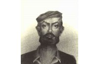
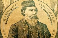 Cretan hero born in Anopolis, Sfakia at 21.6km (SW) Daskalogiannis (GR: Δασκαλογιάννης) - born in Anopolis, Sfakia - started planning a revolutionary liberation movement in Crete in 1769 and completed the preparations for the revolution in Sfakia in the spring of 1770. In 1770, the revolution that had already broken out in other parts of Greece broke out in Crete too. Daskalogiannis, revolt was the first step towards freedom from the Turkish occupation in Crete and kept people, hopes from freedom alive. The international airport of Chania is named after this hero.
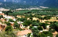 Sfakia, South Hania at 21.6km (SW) Anopolis is a small village, built on a small but fertile plateau, 12 km west from Sfakia at 600 m above sea level. There are still traces of the ruins of the ancient city that prospered around the 3rd century BC, who's port was Phoenix (Loutro). Ancient Anopolis was one of the thirty city - states that signed the peace decree with Eumenes B’ in 183 BC. and thus was able to mint its own coins. During both the Venetian and the Turkish occupations, Anopolis was a center for revolutionary activities. It is the birth place of the freedom fighter Ioannis Daskalogiannis who's statue stands at the center of the village.There are three more small settlements, Limnia, Vigle and Pavliana on the same plateau. The mountainous landscape is of outstanding wild beauty. In the village there are rooms for rent and a tavern.The village is worth visiting not only for its natural beauty but also for the opportunity to explore the White Mountains. One of the best hikes is to descent to the shore through the ravine of Aradena, a five hour walk through an imposing ravine that ends up to the wonderful beach of Marmara. 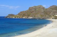 Agios Vassilios, South Rethymnon at 21.8km (SE) One of the nicest sandy beaches of Crete Damnoni is around 6km to the east of Plakias. There are some facilities like umbrellas, sun beds and sea sports and a couple of taverns for drinks and food. Accommodation is also available. Within walking distance to the east there are two smaller beaches nested in small coves. A little farther is the beach of Shinaria which is very popular with the divers.
Image Library
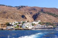
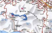 by Richard Ellis at 22.2km (W) 31th August - Katsiveli to Kallerghi via Pachnes- The day dawned with a cloudless blue sky. I was lucky. The route starts with a gentle two km warm up across the Niato plateau before turning more vicious. The next phase is a very steep 700 meter climb up the north east ridge of Kastro. One of the pluses is that you are doing this in the relative cool of the morning - one of the minuses is that you will probably be carrying something like five litres of water. Distance Total (with Pachnes climb): 25.3 km Time: 9 hrs. 30 mins. Mov av 3.3 km/hr Height overnight: 1,518m.(Kalergi) Max. height: 2,453m.(Pachnes) To Pachnes and back:12.1km, time 4hrs 10mins. 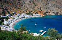 Sfakia, South Hania at 23.3km (SW) Loutro is a small village halfway from Agia Roumeli, where the Samarian gorge ends, to Hora Sfakion, accessible only by boat. The majestic scenery, the calm, the crystal clear water and the hospitality of the local people gave Loutro numerous friends and ardent visitors. No cars, no bikes... nothing to spoil the peace of this historical place. Some small hotels, apartments and rooms as well as a few lovely taverns offer their guests a friendly atmosphere that makes Loutro an ideal place for vacation and relax.
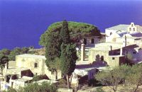 Agios Vassilios, Rethymnon south at 25.6km (SE) It stands 37 km south of Rethimnon, in an imposing landscape which is mentioned at the mid-19th century diary of Th. Spratt (admiral of the British Royal Navy), as "one of the happiest places to withdraw from trials and responsibilities of life".There are lots of legends concerning the foundation of the monastery, which is believed that started during the Venetian occupation of the island. A number of its monks activities made the monastery one of the richest of western Crete and due to its isolated position it played important role in Cretan revolts against the occupying forces. A substantial number of icons and other items is kept in the Museum of the Monastery of Preveli amongst them the miracle - working Eulogistic Cross of Efraim Prevelis.
Image Library
 Rethymnon North at 25.8km (E) Adele village is at a distance of approximately 8 Km east of Rethymnon town located on the road to the Monastery of Arkadi. It is a beautiful small village built in an altitude of 70m above sea level with a population of 350 people. Strolling around the village, through the narrow paved small streets the visitor will come upon beautiful picturesque house yards, freshly whitewashed houses, historical churches and tasteful traditional coffee shops.
 freedom fighter born in Adele at 25.8km (E) Kostis Yiamboudakis was the hero who ignited a fire in the gunpowder storage room of the Arkadi Monastery in November 1866 and won glory for himself and the island of Crete. He was a simple villager with a big heart and great love for freedom.
|
|||
|
| |||


C
O
N
T
E
N
T
S
O
N
T
E
N
T
S