interkriti®
YOUR GATEWAY TO CRETE
HOME
CRETE FACTS
NAVIGATE
EXPLORE

Agia Galini
Triopetra
Kissamos
Chryssi Isl.
Agia Marina
Balos
Gavdos isl.
Georgioupolis
SAMARIA
IDA Mtn
Palaiochora
Agia Roumeli
Sfakaki
Bali
Kalamaki
Matala
Lassithi
Plateau Lendas
Tsoutsouros
Vianos
Myrtos
Sfakia
Plakias
Ierapetra
Makrygialos
ZAKROS
Vai
Sitia
Agios Nikolaos
Elounda
MALIA
Hersonissos
Gouves
Chania
Rethymnon
Heraklion
GORTYN
FESTOS
KNOSSOS
|
|
Crete
List Grid Map
Found
146
- Showing :
61 - 80
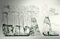 Knossos Palace at 13.1km (S) The Corridor of the Procession is named from the wall painting decorating its east wall and depicting a procession of musicians and other people holding gifts. The floor was very fine. The "Corridor of the Procession", according to Evans, initially led to the "South Propylaeum" and continued on to the Central Court. Today a causeway made of wood, with handrail, stands in its place, so the visitors can follow the same route. Image Library
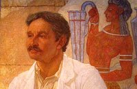 Excavator of Knossos at 13.1km (S) British archaeologist whose name is inextricably bound up with excavations and restoration work at the palace of Knossos. Born as the son of numismatist John Evans, he studied at Oxford and briefly in Göttingen. From 1875 to 1882 he travelled through the Balkans as a correspondent of the Manchester Guardian. In 1884 he was appointed curator at the Ashmolean Museum in Oxford, which post he held until 1908. One year later he became a university don. In 1894 Schliemman's excavations at Troy, Mycenae and Tiryns prompted Evans to visit Crete for the first time, in search of Bronze Age script. The following year he published his first book on Cretan pictographics and pre-Phoenician writing. He set about systematic excavation work after the island was liberated from the Turks (in 1898), having already located the wider area in which to dig. At the same time he toured the length and breadth of Crete. Evans worked at Knossos for no less than 35 years, bringing the palace and countless finds to light. The building's large surface area and shape led him to the conclusion that it had been the palace of King Minos. He thus gave the name 'Minoan' to the civilization he had uncovered, subdividing it into three major periods. In 1911 he was knighted for his excavation activity and extensive work. Alongside the excavations, Evans showed great zeal in restoring the palace and reconstructing the wall paintings that had come to light. For all the intense criticism this part of his work has often attracted, it still stands as a first approach to what is now known as the Minoan palace. The ensuing publications of material added many pieces to the puzzle of Minoan civilization and remain useful research tools to this day. In the course of his last visit to Crete, Evans was given the Freedom of the City of Heraklion. Image Library
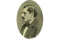 Discovered Knossos at 13.1km (S) Born in 1843 as the youngest son of Andreas Kalokairinos. Having completed secondary education on the island of Syros, he matriculated at the University of Athens School of Laws and attended for one year, but was forced to abandon his studies after his father fell seriously ill and died. Thereafter his interest turned to his father's estates, which he initially managed together with his brother Lysimachos. Kalokairinos later went into soap manufacture, winning awards at world exhibitions. Unfortunately, however, his business enterprises were not destined to be successful to the end; in 1895, having taken out numerous loans at exorbitant interest rates and mortgaged all his estates, he was forced to declare bankruptcy and was thus deprived of the right to engage in commerce. In 1903 he decided to resume his legal studies at university, and was later awarded a a degree. In 1878 his passion for archaeology and classical studies led him to attempt the first systematic excavations at Knossos, which brought the first finds from the Minoan palace to light. These comprised the Kalokairinos private collection, held at the site where the Kalokairinos Mansion (the present-day Historical Museum of Crete) was later built. The finds were destroyed when the first mansion was burnt to the ground during the 1898 riots. In 1869 Minos Kalokairinos married Skevo Kyriazi, with whom he had five children. 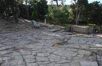 Knossos Palace at 13.1km (S) This area, sited at the north-west edge of the palace, was called the "Theatre" by Evans because its shape reminded him of later theatres. It is a platform and rows of steps that form a right angle. At the base of the stairs is the end of a narrow elevated road that crosses a paved court. Evans believed that the court was used for ceremonies watched by the standing viewers. The elevated paved road continues in the opposite direction. It passes underneath the modern road to Heraklion, connecting the Palace with the Minoan town, which extended to the West and North. Evans named the road the "Royal Road". Along the length of the road are town houses with workshops on the ground floor and residential areas on the upper floor. Image Library
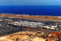 Iraklion ( Nea Alikarnassos) at 13.2km (NW) Heraklion International Airport, "Nikos Kazantzakis" (Greek: Κρατικός Αερολιμένας Ηρακλείου, "Νίκος Καζαντζάκης") or Nikos Kazantzakis International Airport (IATA: HER, ICAO: LGIR) is the primary airport on the island of Crete, Greece. It is located about 5km from the main city of Heraklion. Heraklion International Airport is is one of the biggest in Greece and receives approximately 15% of the total tourist traffic of Greece. There are many airlines currently operating flights from Athens and Thessaloniki to Iraklion (Olympic Airways, Aegean Airlines and others), while during the high season there are flights from/to Rhodes, Mykonos, Santorini and other Greek islands. There are also international airlines that connects Iraklion to other European cities. During the summer season there are numerous chartered flights to Iraklion from all over Europe (mainly Germany, the United Kingdom, Russia, and Holland). During the summer months there is a huge increase in air traffic that peaks in August (approximately 130 flights per day). Major car-rental companies have desks at the airport. Taxi and public bus are available for transfer from/to Iraklion. 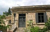 Knossos at 13.3km (S) Villa Ariadne was built at Knossos, Crete, by Sir Arthur Evans soon after he discovered the Minoan palace, when the site was his own private property. The villa became home, in turn, to John Pendlebury, who used it as a base for his excavations at Knossos and his explorations of the island. After Pendlebury's death at the hands of invading German paratroopers, the Villa Ariadne was taken over by General Karl Kreipe, who was living there when he was kidnapped by Patrick Leigh Fermor and his team. Ariadne villa is surrounded by the only existing Greek Edwardian garden, a large oasis of Cretan and other flora and shrubs in specific formations. The garden has been fully studied by the British School of Archaeology with the participation of special architects and agronomists from Heraklion. 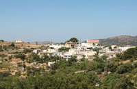 Pediada, Iraklion at 13.6km (SE) Mathia is 11 km to the SE of Kasteli, has 215 inhabitants and lies at 590 m above sea level, in the foothills of the Afendi mountain (1578 m), with the Dikti mountain in the background. The earliest reference to the village can be found in several contracts of 1271 where the notary of Chandax P. Scardon mentions commercial exchanges of grain and wine with residents of the village ‘Mithie’, possibly a misspelling for Mathia. The name derives from the common first name for girls, ‘Mattia’, which in Crete is pronounced ‘Mathia’. Burials in jars of the middle Minoan period were discovered in 1957 close to the village, in a place known as Stavroplaka. To the NW of the village, at Katalimata, a Late Minoan site with important finds and, 200 m further off, a settlement with large walls still in place were also found.There are wonderful Byzantine wall paintings in the two churches of this traditional village, the church of Koimisi tis Panagias (Dormition of Our Lady) and the church of Agios Giorgos. At Metochi, in beautiful surroundings where the historical holm-oak of Ismail Pasha stands among plane trees and running water, there are camping facilities. You can also visit an old factory and several ruined mills. The village boasts of several kapheneions where they serve raki and ‘mezedes’ (tit-bits). There is an active cultural centre, that organizes events especially in the summer, with evenings of Cretan music and theatre plays. The most important and traditional feast is held on the Sunday of Agioi Pantes, 50 days after Easter. Image Library
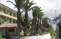
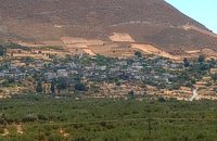
 Archanes, Iraklion at 13.9km (SW) A small traditional town (~4000 people) 15 km south of Iraklion on the foot of the sacred mountain Yiouhtas. Renowned for its excellent wine (from the varieties: vilana, kotsifali and madilari) and the archaeolocical sites and caves. In 1912, Xanthoudides noted the importance of Archanes, but Sir Arthur Evans was the first to characterize the site as palatial, declaring that Archanes was likely a Summer Palace for the Knossos kings. Spyridon Marinatos and N. Platon excavated minor areas in the region, but nothing supported Evans' theory. In 1964, J. Sakellarakis dug trial trenches at the Tourkoyeitonia site and uncovered the first evidence of a palace site. Since 1966, Archanes has been excavated by the Greek Archaeaological Society under the supervision of John Sakellarakis and Efi Sapouna-Sakellarakis. The small town of Epano Archanes, one of the most famous places of the Cretan land, with its colorful courtyards, teaches culture, taste, tradition, colors, aromas and life itself. The silvery grays of the olive groves, the red, pink, salmon and tiled walls, the blue and green shutters, the colorful bougainvillea boldly climbing the walls of the houses, the manicured flower beds, but also the elaborate, colorful signs in coffee shops and grocery stores. All this makes Archanes the most colorful village of Crete, but also of Greece. The town is full of atmospheric neighborhoods with well-maintained houses, painted in cheerful colors. At each step the visitor learns more and more about it. That's why the locals have taken care of it: the Folklore Museum, the Archaeological Museum, the sculpture workshop, the Museum of Cretan History and Tradition just outside. Image Library
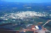
 Knossou Av. Iraklion at 13.9km (W) The General Hospital of Heraklion "Venizeleio & Pananio", named after the great statesman Eleftherios Venizelos, is one of the largest hospitals in Crete with 500 organic beds. It is located 4km away from Heraklion center on the road to Knossos, and occupies an area of 25,000 sq. meters. Venizeleio hospital provides high quality health services to citizens in a friendly and human environment. It was established in 1953 by a donation of Cretans of America and worked initially for Pulmonary Diseases. It was for many years the major hospital in East Crete. Telephone: (+30) 2813 408000 Website: www.venizeleio.gr/ 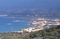 Pediada, North - East Iraklion at 14km (E) The famous tourist resort with all types of accommodations. Great beaches and a lively party atmosphere particularly in August. Becomes pretty quiet and peaceful during the rest of the season and there is a nice and picturesque part of the old village that preserves the traditional character. Malia has also a significant agricultural production and is famous for its bananas, potatoes and bottled water.
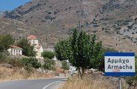 Pediada, Iraklion at 14km (S) Armacha (GR: Αρμάχα) lies at 490 m above sea level, at a distance of 7km from Kastelli, with 110 residents (census 2001) and is first referred to by Barozzi in 1577. Armacha is rich in the production of agricultural and livestock products. The Metropolitan Bishop, Tirnovos Voulgaria Ilarionas Kabanaris Sinitis was born, and is also buried here. A man of advanced learning, he wanted to translate the Bible to Demotic Greek. 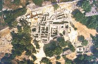 Archanes at 14.1km (W) Excavations at Phourni have brought to light 26 buildings, most of which had funerary use. The cemetery was used from 2400 B.C. until 1200 B.C. and each complex had more than one architectural phase. Most of the funerary buildings were used for many decades and contain successive burials. Excavations were begun in 1964 by Efi and John Sakellarakis and have been continued until today (1995) with short interruptions. Most of the buildings are preserved in good condition. 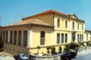 Archanes at 14.3km (W) An excellent specimen of a specialized building, one of the first structures erected during the period of the Cretan State. It was designed by the architect Salivero, one of Prince George's officials. The plans were completed in 1901 and the construction was accomplished thanks to donations of rich Archanians living in the U.S.A. The building is Pi-shaped in plan, has two storeys and a basement, it is built of stone and its roof is partially wooden and covered with tiles. It is a monumental but well balanced structure with many harmonic and elegant Neoclassical features. Since its construction, the building has been used as a school. During the German occupation it housed General Muller's division. Source: The Hellenic Ministry of Culture 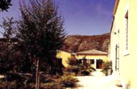 Archane, Iraklion at 14.5km (SW) The Archaeological Museum of Archanes opened in 1993. It occupies an area of 570 square meters and it is located at the Tzami quarter in the center of the settlement. There, for the first time in Crete, the archaeological finds from a single site are exhibited. While the exterior spaces of the building were adapted to a tasteful ensemble, in resemblance with the impressive modesty of the environment and the traditional ochre and rosy colour tonations of Archanes. The interior was thus arranged as to accommodate the most modern mode of exhibition, especially attractive for the visitor. 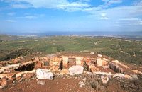 Archanes at 15km (W) Anemóspilia (GR: Aνεμόσπηλια). Anemospilia is an archeological site at the northern foot of Mount Yuchtas, in the prefecture of Heraklion in Crete. A rectangular building has been found which dates from the Minoan era and was destroyed by an earthquake in the 17th century BC. The building with three narrow chambers, each opening into a long corridor to the north, which extends along the whole width of the building. The area is enclosed with a stone wall and the whole structure has been interpreted as a shrine; in the central room was found a "xoanon" (statue) of the deity worshiped here. In the west room, where the altar stood, was uncovered, according to the excavator, the first human sacrifice to have ever taken place in Minoan times. (although this view has been challenged). The building at Anemospelia was used for only half a century, as it was suddenly destroyed by an earthquake in the middle of the 17th century B.C. The site was excavated in the summer of 1979 by John Sakellarakis. 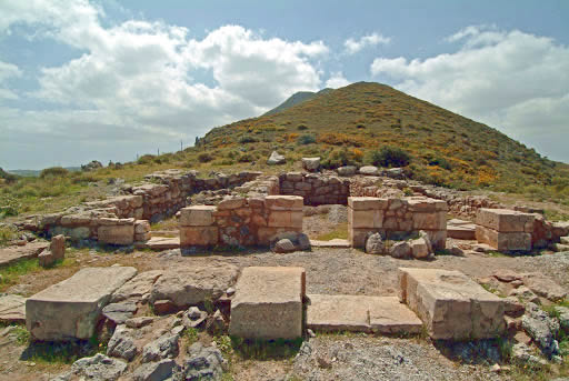 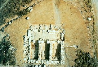 Aerial view 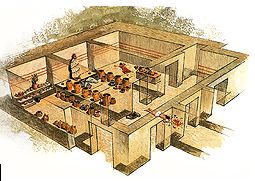 Shrine model Links: Minoan Religion (Foundation of the Hellenic World) 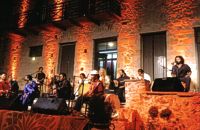 Houdetsi, Iraklion at 15.4km (SW) The Musical Workshop "Labyrinth" organizes seminars, concerts and various creative activities around modal traditional musics of the world. Labyrinth Musical Workshop was founded in 1982 by Ross Daly, with the goal of initiating young people, primarily, into a creative approach to traditional musical idioms from various parts of the world.  North - Central Crete at 15.5km (W) Iraklion (Heraklion or Herakleion GR: Ηράκλειον) is the largest urban centre in Crete, the capital of the region and the economic centre of the island. The first European civilisation, the Minoan civilisation, flourished on this land 5000 years ago. Currently the population of Iraklion is approximately 150.000 people. It is a very dynamic and cosmopolitan town, particularly during the summer period when thousands of visitors can be seen shopping in the market or visiting the museums and other places of interest. Today Heraklion is the top choice for tourist destinations in the Mediterranean. The city is also the commercial and scientific centre of the island. During the last 20 years the city has made remarkable progress in the academic and technological fields...
Image Library
 Pediada, Iraklion at 15.5km (S) Geraki (GR: Γεράκι). This lovely village of 375 inhabitants is located on the western slopes of the Lassithi mountains between the peaks of Afendi (1578 m) and Sarakinos (1588 m) in a beautiful glen, 520m above sea level and only 9km SE of Kastelli. It features an interesting Byzantine church, dedicated to the Archangel Michael (Archangelos Michail) with wall paintings that have not been maintained and some interesting (movable) icons by the local painter, Sepis. The active cultural centre of Geraki organizes many events during the summer season. Twice a year the village has a typical Cretan feast in honour of its patron saints: Agia Paraskevi on July 26th and Michail Archangelos on 8th November. The village produces agricultural products and great cheese that led to a specific cheese celebration. From Geraki you can also reach the lovely chapel of Agia Anna, driving through a particularly beautiful landscape with a spectacular view over the Geraki glen and fresh running water, a place ideal for a picnic. Image Library
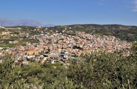
 Central Iraklion at 15.6km (S) The town of Arkalochori (GR: Αρκαλοχώρι) with a population of 2.881 is located 33km away from Heraklion, on the provincial road linking Heraklion and Viannos, at 395m above sea level. Its inhabitants are mostly involved in agriculture, but in commerce and arts as well. Arkalochori is one of the most developing towns in the prefecture of Iraklion both in economic and cultural sectors and is the administrative center of the area. Events such as the Pancretan Agricultural and Commercial Exhibition, that takes place here are of great significance and interest for the whole island. The town offers a full range of modern facilities to its residents and visitors.
Image Library
 Pediada, Iraklion at 15.7km (E) Krassi is a small village 47 Km's from Iraklion and 17 km from Malia at an altitude of 600 m.asl, on the way to Lassithi plateau, and is administratively part of the Municipality of Malia. The village is one of the prettiest in Crete, with a lot of springs. Due to the free running water , it is covered with walnut trees, plane trees and all kinds of vegetation. Next to the spring in the middle of the village is one of the oldest and biggest plane trees in Crete (its root has a circumference of 22 meters!). |
||
|
| ||


C
O
N
T
E
N
T
S
O
N
T
E
N
T
S