interkriti®
YOUR GATEWAY TO CRETE
HOME
CRETE FACTS
NAVIGATE
EXPLORE

Agia Galini
Triopetra
Kissamos
Chryssi Isl.
Agia Marina
Balos
Gavdos isl.
Georgioupolis
SAMARIA
IDA Mtn
Palaiochora
Agia Roumeli
Sfakaki
Bali
Kalamaki
Matala
Lassithi
Plateau Lendas
Tsoutsouros
Vianos
Myrtos
Sfakia
Plakias
Ierapetra
Makrygialos
ZAKROS
Vai
Sitia
Agios Nikolaos
Elounda
MALIA
Hersonissos
Gouves
Chania
Rethymnon
Heraklion
GORTYN
FESTOS
KNOSSOS
|
|
Crete
: Regional Interest
List Grid Map
Found
55
- Showing :
1 - 20
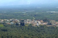
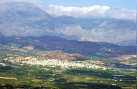 Messara plain, South - East Iraklion at 0km (N) The administrative center of the Messara Valley. Moires (GR: Μοίρες) is the biggest town in the Messara Valley with a population of approximately 5000 people. It has a police station, magistrate's court,post office, public PTT office, health center, and offices of most Greek major banks.
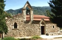
 Mires, Messara Valley at 2.5km (NE) It is located north of Mires close to a small gorge, with springs and covered with trees. There are many churches in the village the most important one being the church of Agios Nikolaos, a domed church dated to the 13th century. The walls of the temple are hand painted with biblical scenes and pictures of saints
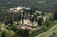
 Messara, Iraklion South at 2.9km (N) Gallia is one of the oldest villages of the area. It is mentioned as a location in the Venetian records as early as 1577, and as a village with 120 residents since 1583. The renaissance tower in the village (still imposing although rundown) and the water fountains in the Kapeloniana area are proof of the passing of the Venetians. Part of the village, called Monohoro, is mentioned as early as 800 A.D. 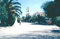 Moires, Messara at 3.6km (W) The monastery of Panagia Kaliviani is located at the 59th km on the road Iraklion-Phaistos. The monastery was built during the second Byzantine period. The small Byzantine chapel was painted with frescoes but most of them are today destroyed. The chapel was deserted until, during the Turkish occupation in 1873, an old small icon of the Annunciation of the Holy Mother was miraculously found there.and the monastery became a place of worship. 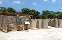 Palace and Archaeological Site at 5.4km (W) The archaeological site, the palace, the findings - The Festos Disc. According to mythology, Phaistos (or Festos) was the seat of king Radamanthis, brother of king Minos. It was also the city that gave birth to the great wise man and soothsayer Epimenidis, one of the seven wise men of the ancient world.Excavations by archaeologists have unearthed ruins of the Neolithic times (3.000 B.C.).
Image Library
 Voroi, Messara, Iraklion at 5.8km (W) The exhibited objects in the Museum come from all over Crete. These objects show that the folk culture of Crete is characterized by an amalgam of influences in which Minoan (2000-1000 BC), Archaic (1000-500 BC) and Byzantine models prevail, especially in agriculture, stock breeding, pottery and basketry.
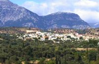
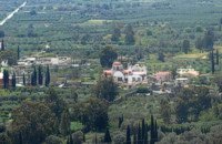
 Messara, Iraklion South at 5.8km (W) Vori is a beautiful, traditional village of the county of Pirgiotissas in the Messara Valley. It is located 60 km south of Iraklion and in the western part of the Messara Valley. The village stretches in a slope, by the side of a small river. The archaeological site of Phaistos is 2 km to the south and the coast of Messara 4 km to the west.
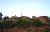
 Village in Messara plain at 6.3km (E) Mitropoli (GR: Μητρόπολη) is a small village in the archaeological site of Gortyna in Messara plain. The village is mentioned for the first time in the Ducal archives of Candia in 1368 and later in the census of 1577 by Fr. Barozzi and in 1583 by Castrofylaka. Early mention of the settlement is to document the Ducal Archive of Candia in 1368, also mentioned by Fr. Barozzi in 1577 with the name and the Mitropoli Kastrofilakas in 1583. According to the census of 2001 it has 382 inhabitants. Main occupations of the inhabitants is the cultivation of vines, olives, vegetables, cereals and citrus fruits. At its north borders are located the ruins of the first cathedral of St. Titus, in which it owes its name.(Mitropoli = Cathedral). Image Library
 Messara, Iraklion South at 6.8km (E) Located in the valley of Messara, Gortys or Gortyn (GR: Γόρτυς or Γόρτυνα) is a must visit for all visitors to Crete. It was inhabited during Bronze Age times, but its rise to glory came almost a millennium after the downfall of the 'Minoans'. Gortyn was a prosperous city from around the middle of the 5th century BC through to the early 9th century AD, when it was finally destroyed by the Saracens (824AD), never to be rebuilt.
Image Library
 Messara, Iraklion South at 7km (SW) Its 1000 years history comes to life for the visitor, who has the chance to admire its monuments, and old houses, perfectly preserved through the centuries. In the village square , you can sit and enjoy your coffee in the traditional coffee shop, while children can play in the playground next to the school. You can also visit the church of Agios Ioannis in the same square. There are quite few rooms for rent in the village and tavernas serving traditional Cretan dishes.
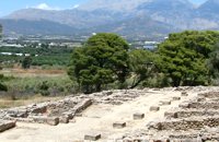 Archaeological Site in Messara, S-W Iraklion at 7.4km (W) The "Royal Villa" at Ayia Triada which is situated very close to Phaistos, was built in about 1550 BC. i.e. just before the new palace at Phaistos, and was destroyed by fire in l450 BC, like all other important Minoan centres. It succeeded the first palace at Phaistos as the economic and administrative centre of the regions depriving the new palace there of this role, and appears to have had connections with Knossos. The two wings, with an open-air space between them, consisted of groups of interconnecting rooms (polythyra), storerooms and stairways. On the site of the ruins, a Mycenaean megaron, the so-called "Agora" and an open - air shrine were subsequently built. In the villa's disaster layer from the fire in 1450 BC, excavation revealed a valuable group of exceptional works of art, precious materials, records in Minoan script and seals. The famous black serpentine vessels, the "Harvesters' Vase", the "Boxers' Vase" and the "Chieftain ‘ s Cup", the wall paintings depicting the natural landscape, the sarcophagus, the bronze and clay figurines of worshipers and the copper ingots from the Treasury are among the most noteworthy findings. 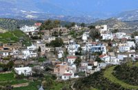 Messara, Iraklion South at 7.8km (W) Kamilari is a quiet, traditional village, with a panoramic view to the endless olive groves of the Messara valley on the one side, and to the Libyan sea on the other side. It has been inhabited since the Minoan period. One of the seven wise men of the ancient world, Epimenidis, a great wise man and a soothsayer, lived in a small community outside Kamilari, called Metohi.
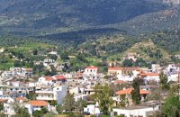
 Messara, Iraklion South at 7.8km (E) Agioi Déka (GR: Αγιοι Δέκα) is a town with 820 inhabitants in the plain of Messara, 170m above sea level, 43 km from Heraklion town and very close to the archaeological site of Gortyna. Its people are occupied mostly in agriculture - vines and olive trees. In the area there is is the oldest olive grove in Crete. The town is built on the ruins of the ancient town of Gortyn where the Holy Ten Martyrs have been martyred. 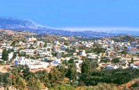 Messara, Iraklion South at 9.2km (SW) The village of Pitsidia is located 65 km southwest of Iraklion at an altitude of 80 m a.s.l, just before the magnificent bay of Messara. The village with aproximately 700 inhabitants is the oldest village of the area and is refered (by S. Spanakis) that it was the place where the soldiers of Nikiforos Fokas, commander of the Byzantine army, settled. The army, famous for its bravery, came from Pisidia of the south Asia Minor, and this is probably the origin of the name Pitsidia.
Image Library
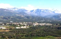
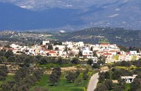
 Kenouriou, South Iraklion at 9.3km (N) Zaros (Greek: Ζαρός), at an altitude of 340 metres, is a town with a lake and gorge nearby. It has a couple of hotels and it is 44 km from Heraklion at the southern foothills of Mountain Psiloritis. The population of 3,400, produce olive oil, sultanas, vegetables and spring water. There are a couple of fish farms that serve both trout and salmon. In Zaros, there are cafes near Lake Votomos, as well as a tavern that serves fresh trout called I Limni (The Lake). Close by is Rouvas Gorge, which is part of the Psiloritis mountain range and is on the hiking route known as the E4 European Walking Path. Nearby Zaros are traditional water mills which have been working since the 16th century, as well as archaeological sites and monasteries. Zaros is also famous for its water "ZAROS" bottled by a company called Votomos SA. 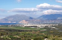 Messara, Iraklion South at 9.8km (W) The town of Timpaki (GR: Τυμπάκι) is located in the west edge of the plain of Messara, 65.3km away from the city of Iraklion. It is a rich and busy town with significant economic activity especially due to the early vegetables production in the wider area. There are banks, a post office, medical centers, stores, schools, hotels, restaurants, ect to cover both the needs of the locals and visitors.
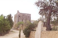
 Voriza, South - West Iraklion at 9.9km (N) Close historical bonds link this monastery to that of Vrontisiou. The Varsamonerou Monastery lies in the surrounding fields of the village Voriza, 54.5 kms from Heraklion. The monastery is abandoned and, though its cells have been destroyed, its church has some of the most remarkable wall paintings in Crete.
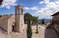 Zaros at 10.3km (N) This is one of Crete's most famous monasteries. It played an important role during the years of the Cretan Renaissance, both in the letters and the arts, and, during the last centuries of Venetian rule, it was known for its many scholars, artists and venerable monks.
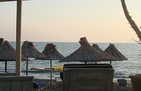 Messara bay, Iraklion South at 10.7km (W) A small coastal village with a long sandy beach is becoming very popular with tourists due both its natural beauty and its proximity to Phaistos, Gortys and other important sites. There are quite few hotels, apartments etc and taverns, cafes by the beach.
 Messara plain, South - East Iraklion at 10.9km (SW) The monastery of Odigitria is a monastery of great importance and historical value and one of the oldest in Crete. It is located at the west edge of the Asterousia mountains at an altitude of 250 m. The monastery was surrounded by walls, part of them still stands. The temple of the monastery is dedicated to the assumption of Holly-Mother and to the Saint Apostles (Peter & Paul). Inside the temple there are valuable frescoes, icons of famous painters and iconostasis. The monastery is connected with the legendary freedom fighter 'Ksopateras' (1788 - 1828) In the area of the monastery at Agioi Eftihianoi was found an ancient (Early Minoan) cemetery. |
||
|
| ||


C
O
N
T
E
N
T
S
O
N
T
E
N
T
S