interkriti®
YOUR GATEWAY TO CRETE
HOME
CRETE FACTS
NAVIGATE
EXPLORE

Agia Galini
Triopetra
Kissamos
Chryssi Isl.
Agia Marina
Balos
Gavdos isl.
Georgioupolis
SAMARIA
IDA Mtn
Palaiochora
Agia Roumeli
Sfakaki
Bali
Kalamaki
Matala
Lassithi
Plateau Lendas
Tsoutsouros
Vianos
Myrtos
Sfakia
Plakias
Ierapetra
Makrygialos
ZAKROS
Vai
Sitia
Agios Nikolaos
Elounda
MALIA
Hersonissos
Gouves
Chania
Rethymnon
Heraklion
GORTYN
FESTOS
KNOSSOS
|
|
Crete
List Grid Map
Found
54
- Showing :
41 - 54
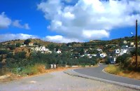 Sitia, East Crete at 24.1km (E) The village of Papagianades (GR: Παπαγιαννάδες) with ~160 inhabitants, is situated in the area of Lefki at an altitude of 480 m above sea level, approximately 90 km from Agios Nikolaos and 19 from the town of Sitia. It was first recorded in an Egyptian census in 1834 with 8 Christian families. It was also recorded by Chourmouzi Byzantios in 1842. In the 1881 census the village is recorded with a population of 77 pertaining to the Community of Handras. The Ai Lias hill just before entering the village is of local interest as well as the Monastirakia, a ruined Minoan settlement. There is also the church of Panagia Eleousa with frescoes dated back to the 14th century. The sightseer can sit and relax at the marvelous Panteli, a place in a gorge with lot of trees, joining the villages of Papagianades and Maronia. The chapel of Virgin Mary is worth visiting as well. 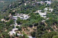 Ierapetra, Lassithi at 24.1km (W) A small village built at an altitude of 540 m in the south parts of the mountain Dikti at the borders of the province of Ierapetra-Viannos. The imposing mountains above the village, the south horizon among the olive-covered hills and in the lower villages, the cool climate create in you a sensation of bodily and spiritual well-being at this balcony of the Cretan nature. Five settlements, two of them uninhabited today, constituted the Community of Riza, now a Local Department of the Municipality of Ierapetra. 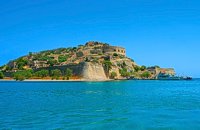 Elounda, Mirabello bay, Lassithi at 24.3km (N) The island of Spinalonga (Gr: Σπιναλόγκα), officially known as Kalydon (Καλυδών), is located in the Gulf of Elounda in north-eastern Crete, in Lasithi prefecture, next to the town of Elounda. The official Greek name of the island today is Kalydon. Originally, Spinalonga was not an island, it was part of the island of Crete. During Venetian occupation the island was carved out of the coast for defense purposes and a fort was built there. A popular name for the island since Venetian rule is Spinalonga. During Venetian rule, salt was harvested from salt pans around the island. The island has also been used as a leper colony. Spinalonga has appeared in novels, television series, and a short film.
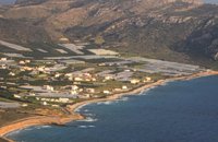
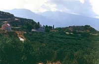 Sitia, East Crete at 24.5km (E) Etiá (or Ethiá GR: Ετιά) is a small settlement situated 2 klm away from the village of Papagianades driving to the village of Armeni. In a Venetian census was recorded with a population of 564. The village of Etia was at peak of its power around the Venetian occupation and from the presence of the St. John and St. Aikaterini churches one assumes that the village also existed through the Byzantine period as well. The village used to be private property of the De Mezzo family, a venetian family, where they built their three-storeyed house, the Seragio Serai House, which used to host Turkish officers as well during the Turkish occupation and can be seen nowadays. This House is considered to be one of the most important samples of the Venetian architecture in Crete. The church of St. Aikaterini used to be occupied by the Turks as a mosque until the Cretan revolution in 1897. At the south of village of Etia there is the hill of Etiani Kefala at an altitude of 715 m. where it used to be a sacred place but unfortunately nowadays looted. 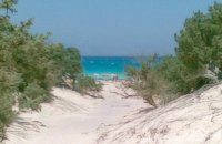 Ierapetra at 25.2km (S) A picturesque uninhabited small island of cedar forest, tempting golden beaches and the well preserved old church of Agios Nikolaos, only 8 miles off the port of Ierapetra, to the south. From the middle of May to the end of October, there are daily boat cruises to Chrissi island, departing from Ierapetra and Makrygialos. There is a bar restaurant at the south beach and a beach bar at the northern beach also known as "Golden Beach". The island belongs to the NATURA network due to its rare combination of ecosystems which form the habitats of several endemic species.
Image Library
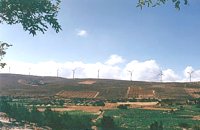 Sitia, East Crete at 25.7km (E) The picturesque hilly village of Arméni (GR: Αρμένοι) is situated at the plateau of Ziros, 27 km from Sitia through Handra and 23 km through the villages of Papagianades and Etia. It was first recorded in a venetian census in 1583 with a population of 428. Today the village has approx. 400 inhabitants. The sightseer is impressed by the numerous windmills in the area. The church of Agia Sofia which used to be one of the most important churches of the Eastern Crete is also in Armeni. Amongst its icons, the Holy Mother presents interesting art features. The Cave of Holy Spirit is also in the area of the village of Armeni. In the wider area you can also visit the Etia settlement. 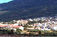 Mirabello, Lassithi at 26.1km (NW) Neapolis is located 15 km westwards of Agios Nikolaos on the way to Heraklion from where it is roughly 50 km far. Neapolis is built in the green valley of Mirabello. In the period of the Venetian domination its two settlements were named "New Village". But when the seat of the Prefecture was transferred from Fourni to the “New Village” this last was renamed to Neapolis. Neapolis was maintained as the capital of the prefecture of Lasithi till 1904. After that date Agios Nikolaos became the new capital. 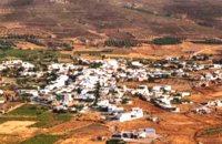 Sitia, East Lassithi at 26.6km (E) The village of Handras (or Chandras (GR: Χανδράς) is in the Municipality of Lefki at the Armeni-Handras plateau and 27 km from the town of Sitia. First recorded in a venetian census in 1583 as Candra and Chandra with a population of 399 like today. Ancient Minoan sites were found at the Plakalonia area as well as at the Gras and Katrani places. There is a peak sanctuary at the hill of Xykefalo between Handras and Kasteliona at an altitude of 705 m. In spite of its looting a lot of ancient objects were found. The cave of Panagia Gouda is at the Handra region. This region includes the communities of Voila, Agios Panteleimonas and Pano Panteli. At Pano Panteli there is an old church the Metamorfosis in which there is an inscription that says: Petro Abramo was here in 1486. 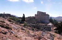 Sitia, East Lassithi at 27.3km (E) The settlement of Voila (GR: Βόϊλα) is 1km away from the village of Handras. It is a medieval deserted village protected by the Greek Archaeological Authorities. Passing through the village's alleys you can still see the ruins of old houses and their rooms, their venetian features and through this sacred silence of the place you have the impression that you hear the Byzantine king, the medieval knight or the Turk fighter gallop away. The name of the village probably comes from the Byzantine word VOILAS or VOLIAS meaning the nobleman, the land owner. In a census carried out by Kastrofilaka in 1583, the village of Voila had a population of 301. Many elements show that the village belonged to the venetian family of Zenos which during the Turkish occupation adopted the Ottoman religion and was renamed.The tradition says that he was the owner of a Castle in Voila which has an external inscription with the date 1153 equal to 1742 of the Christian diary. At the south of the castle there is a ruined church known as the church of Ginali. Other attraction at the area is the old painted church of St. George dated back to the 15th century. From the inscription it is obvious that there is a family tomb of Salamons. The Solomons of the island of Zakynthos where our national poet Dionisios Solomos comes from, are believed to having been descended from the Salamons of Sitia. At the top of the hill overlooking the village there is a fortress dated back to the Venetian occupation of the island of Crete. Image Library
 Sitia, East Crete at 27.4km (E) Goúdouras (GR: Γούδουρας), is a coastal settlement near the Cape of Erythraio at the Libyan Sea. It is developing to a sea resort, there are sandy beaches, taverns and lodgings and a small shelter for fishing boats. There is also a remarkable production of early vegetables in green houses.
 Sitia, East Lassithi at 28.2km (E) Piskokéfalo (GR: Πισκοκέφαλο), a principal village located 3 km south of Sitia. Piskokefalo is the birth place of the great poet Vincentzos Kornaros, who wrote the masterpiece of Medieval poetry, "Erotokritos". The village is mentioned at the census of 1577 by Fr. Barozzi, and became the seat of the commanding officer, after the destruction of the town of Sitia in 1538 by the pirate Chairentin Barbarossa. Nowadays Piskokefalo is a beautiful village where a stop is worthwhile. The visitor can see the house of Kornaros, enjoy a coffee or a meal at the village's square, visit the spring at Zou, the old water mill, the church of "Agia Anna" and the small chapel of "Panagia Trapezounta".  masterpiece of the Cretan Renaissance at 28.2km (E) Erotokritos (GR: Ερωτόκριτος) has been characterized as a masterpiece of the Greek language which unites the magic of myth and a deep understanding of everyday life. It expresses the "threefold ideal which is bravery, beauty and wisdom." A work rooted deeply in authentic Greek traditions, humanity, true feeling and pure love for life and freedom. The story takes place in Athens where King Herakles lives with his wife Artemis and their very beautiful daughter Aretousa, with whom the handsome and brave young man Erotokritos, son of the king's advisor, has fallen in love. After many difficulties and trials, the couple is married amidst celebrations and magnificent contests. The world of this work is the ideal Greek world of friendship, pure feelings, authentic Greek traditions. It is the world of the beauty of Athens and Crete which is "the throne of virtue and the river of wisdom." The language of this work is authentic Greek and Cretan, a synthesis and conscious effort of the poet to express lofty human feelings and values with simplicity, directness and truth. The poem was written by Vitsentzos Kornaros (1553-1613/14) a noble Cretan from Sitia with a very strong presence in Greek letters.  Cretan poet of the Greek Renaissance at 28.2km (E) Vitsentzos or Vikentios Kornáros (GR: Βιτσέντζος or Βικέντιος Κορνάρος) or Vincenzo Cornaro (March 29, 1553 – 1613/1614) was a Cretan poet of the Greek Renaissance who wrote the romantic epic poem Erotokritos. He was a leading figure of the Cretan Renaissance. Not many biographical sources exist about Kornaros himself apart from the last verses of Erotokritos. It is believed that he was born to a wealthy family in Trapezonda near Sitia, in 1553, and lived there roughly up to 1590. He then moved to Candia (present Iraklion), where he married to Marietta Zeno. Together they had two daughters named Helen and Katerina. Image Library
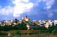
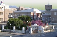 Sitia, Lassithi at 29.5km (NE) The hospital provides full medical treatment and services. Website: www.ghsitia.gr Xerokamares, 72300 SitiaTel : 2843 3 40 100 FAX : 2843 0 25 352 - 2843 3 40 200 E-mail: ghsitia@ghsitia.gr |
||
|
| ||


C
O
N
T
E
N
T
S
O
N
T
E
N
T
S