interkriti®
YOUR GATEWAY TO CRETE
HOME
CRETE FACTS
NAVIGATE
EXPLORE

Agia Galini
Triopetra
Kissamos
Chryssi Isl.
Agia Marina
Balos
Gavdos isl.
Georgioupolis
SAMARIA
IDA Mtn
Palaiochora
Agia Roumeli
Sfakaki
Bali
Kalamaki
Matala
Lassithi
Plateau Lendas
Tsoutsouros
Vianos
Myrtos
Sfakia
Plakias
Ierapetra
Makrygialos
ZAKROS
Vai
Sitia
Agios Nikolaos
Elounda
MALIA
Hersonissos
Gouves
Chania
Rethymnon
Heraklion
GORTYN
FESTOS
KNOSSOS
|
|
Crete
: Regional Interest
List Grid Map
Found
76
- Showing :
41 - 60
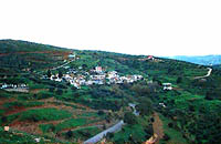
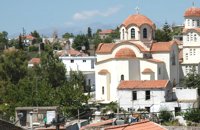 Pediada, Iraklion at 17.1km (W) Apostoloi (GR: Αποστόλοι) is a village in the area of Kasteli, 360 m above sea level. It has about 490 inhabitants, and is located on the 32 km of the road leading to Kasteli in the NW part of Apostolianos Kampos, among vineyards and olive groves. Until recently tannery was a main activity among the villagers. The earliest reference to the name is to be found in a contract drawn in 1279, where Sancti Apostoli et Sophoro were lands belonging to the Venetian lord Leonardus Gradonicus, who gave them and leased them to Petro Quinino. There is another mention of the name in a document dated to 1378. It is also quoted by Fr. Barozzi in 1577 as forming part of the Pediada district. The name of the village finds its origins in the name of an old church dedicated to the Saint Apostles. The present church was built on the same site in the 19th century, in 1876. The church of Agios Giorgos is Byzantine and has wall paintings. According to village tradition, on the night of Easter in 1841, the Turks caught the Cretan leader of the revolution for the Eastern part of the island, Giorgos Vassilakis, or Vassilakogiorgi and hanged him from a fig tree.The village kapheneions serve particularly good raki and on June 29th there is a great feast in the honour of the Saint Apostles, Peter and Paul. 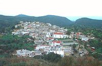 Gouves, Iraklion at 17.4km (NW) At a height of 320 m above sea-level, Kalo Chorio (GR: Καλό Χωριό) λιεσ 25.7 kms. from Heraklion, to the right at the cross-roads at km 16.7 on the National Road to Agios Nikolaos and on the road to Gouves- Koxare- Kalo Chorio. The present name does not figure in old Venetian documents, though there is a reference in the 1367 Duke’s archives of Chandax to a Kalo Horio, without however naming the district. The villagers maintain that the village was called Stravorina in the old days, and indeed there is a reference by Barozzi in 1577 to a village Stravorina in the district of Pediados. In the 1583 Register, the village Stravorina is mentioned as having 76 inhabitants and in the Turkish census of 1671 Istavrine is quoted as having 21 "charatsa" (A Turkish word referring to a tax paid by the head of each family; hence 21 families). However, Chourmouzis Vizantios in 1842 mentions Kalo Chorio, the present name was therefore given in the decade 1830-1840. The village counted 298 inhabitants in 1981 which is also the current population. The Maza hill-top, south-east of the village, is 457 metres high. According to archaeologists (among them the famous N. Platon) and on the basis of recent finds, the name Maza comes from pre-Hellenic years and means Mother Earth. The pile of stones on the hill was, according to N.Platon, a town from the 10th to the 8th c. BC. The highest part was undoubtedly used as a shrine in Middle-Minoan years, and clay figurines and offerings were found there. The shrine lay quite close to the town. The shrine stopped being used in Proto-Geometric years. Northeast of the village, by the country road that leads from Kasteli to Hersonissos, traces of ancient installations have also been found along with remnants of water tanks by a source that is still in use today. These water tanks, probably belonged to Hersonissos aqueduct, parts of which are still visible today in Aposelemi valley. There is as well an interesting gorge close to Kalo Chorio, in the valley of Aposselemis river, worth seeing for nature lovers. 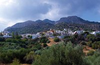 Ierapetra, Lassithi at 17.5km (SE) Mournies (GR: Μουρνιές - meaning: mulberry trees) is a village of the western Ierapetra. It is located north of Myrtos, and 25 kilometers away from Ierapetra at 275m (elevation), built on the southeastern outskirts of the Lasithi mountains, with beautiful views of the Libyan Sea and the plains of Ierapetra. It has a mild climate, without extremes, ideal both for permanent residence and for holidays. The landscape is hilly plenty of olive trees. In the 2001 census it had 83 residents. Mournies is a beautiful, historic, picturesque and traditional village with cafes, a square with a war memorial, an old fountain, and narrow streets branching off the main street of the village. Mournies was named after the Mulberry tree which however is not abundant in the area. 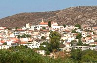 Pediada, Iraklion at 17.7km (NW) The village of Smári (GR: Σμάρι) is a traditional Cretan village, only 10 km away from Kasteli and has 375 inhabitants. In it you will find beautiful old stone houses that have been restored, picturesque little alleys, ruins of older buildings and pottery workshops where you can purchase copies of Byzantine and Minoan ceramics. There are also some interesting churches with wonderful frescoes like the one dedicated to Sotir Christos, the Koimisi tis Panagias and Agios Giorgos. The earliest reference to the village of Smari dates back to 1375. There is a lively Cretan feast on July 20th in honour of Profitis Ilias, with much rejoicing, singing and dancing. 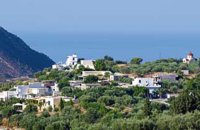 Ierapetra, Lassithi at 18km (SE) A stately village built in settlements, 22 km away from Ierapetra, at an altitudeof 225 m, next to the Ierapetra-Vianos provincial road. A green landscape,overgrown with olive trees, with an unlimited view of the Libyan Sea, to thesurrounding areas Koleitos, Kakon Oros, to the beaches Vatos and Kallikovrechtis.An almost abandoned village, with old houses built of stone, with chiseled doorframes and coats of arms bearing the Christian cross and proving its old gloryand history.Giannis Dimitromanolakis, an author from Gdohia, writes:“Gdohia sprouted right opposite the beach of the Libyan Sea. Nothing wouldhave been better for the pirates, who, like diabolical ghosts, emerged into thenight to kill and prey. The village’s history is dipped in blood, as it often sufferedfrom the raids of the pirates from the Barbary Coast. It took the name Gdohiafrom the catastrophes, from the verb “gdyno”, to skin, to set fire, to devastate.”Gdohia’s course in time has evidence of struggles, sacrifices and holocausts toshow. It was not only exposed to the pirates but it was situated on the naturalsouth passage going from the Viannos area to the Ierapetra area. This meantthat the hordes of barbarous conquerors burnt and devastated it, along withthe other Symiana villages, as they are called, in the West Ierapetra.Gdohia’s settlements are built leaving a distance between each other: KatoGdohia or Pitropiana, taking their name from the Epitropakis family livingthere, Pefkiana or Grysboliana, from the Grysbolakis family, Dimitromanolianafrom the Dimitromanolakis family, Daskaliana from the Daskalakis family,Papadiana from the Papadakis family. Great stonecutters, stoneworkers,famous for their art, Gdohia’s residents built the mansions of the whole areaand the famous bridge of Myrtos using stones from the quarries of Kolleitos.The miraculous church of Panagia (Our Lady) Evaggelistria of Gdohia, a workof art and a great ecclesiastical monument is also built by Gdohia’s residents.Gdohia village, once the seat of a Community, today a Local Department ofthe Municipality of Ierapetra, presents an exceptional sight-seeing interest. Itprovides natural landscapes, beautiful beaches, picturesque little churches onthe hills, a spacious square with palm trees, seats and a war memorial forthe fallen fighters of the liberation wars. In the 1881 census, 296 residents areregistered and 73 in 2001. Gdohia’s permanent residents, along with someforeigners’ families who have bought and renovated old houses, struggle forthe village’s development which gradually acquires the necessary infrastructures.A village with rich history and civilization, with vast olive groves, a nicemild climate, both during summer and winter, it hopes to come back to life.The old mansions, half-wrecked and burned in the German Occupation, standas if they were sculptures, a painting with the deep blue Libyan Sea serving asa background, narrate the flourishing, the glory and the history of Gdohia andwait to be inhabited again.
 Pediada, North - East Iraklion at 18.4km (NW) The most popular tourist resort in Crete. Nice beaches, sights and facilities for all tastes and ages. Together with Malia, are the party places for young visitors. Close to Hersonissos there are three small traditional village, those of Piskopiano, Koutouloufari and Old Hersonissos.
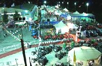 Arkalohori at 18.5km (W) A modern exhibition and congressional centre offering 8000 square meters of total space, 1500 of them being indoors. Among many events that take place in this centre is the Pancretan Agricultural and Commercial Exhibition of Arkalochori held every two years at the end of August. The exhibition attracts a large number of enterprises, manufacturers and services participating and is being visited by over 30,000 visitors from all over Crete. It is considered to contribute essentially in the rapid commercial and cultural development of the wider area. Photo The Municipal Open Theatre Located in the area of the exhibition centre the theatre is of semicircular shape with a capacity of approximately 1000 seats. The facility offers also a canteen, toilets, dressing-rooms for the actors, store room of scene and backstage.The cultural events that the Municipality organises every summer, attract visitors not only from the wider area but also from Iraklion city. Photo Photo 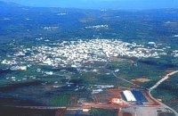 Central Iraklion at 19.1km (W) The town of Arkalochori (GR: Αρκαλοχώρι) with a population of 2.881 is located 33km away from Heraklion, on the provincial road linking Heraklion and Viannos, at 395m above sea level. Its inhabitants are mostly involved in agriculture, but in commerce and arts as well. Arkalochori is one of the most developing towns in the prefecture of Iraklion both in economic and cultural sectors and is the administrative center of the area. Events such as the Pancretan Agricultural and Commercial Exhibition, that takes place here are of great significance and interest for the whole island. The town offers a full range of modern facilities to its residents and visitors.
Image Library
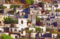
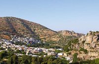 Ierapetra, Lassithi at 19.5km (SE) One of the most beautiful parts of the hinterland of Ierapetra is occupied by the picturesque village of Kalamafka. It is situated on the edge of the Lassithi mountains, an area known for its impressive diversity in landscape. Kalamafka sits at an altitude of 480 meters, 15 kilometers from the town of Ierapetra and 25 kilometers from Agios Nikolaos. Kalamafka is a picturesque, large, and prosperous village surrounded by unique natural beauty. The springs at Kefalovryso, with its plane trees and lush vegetation, as well as its old historical churches, gorges, and springs, attract visitors due to the oasis-like coolness it offers in this otherwise dry and hot region. The village's wealth lies in its water sources and the vitality of its residents, who resist urbanization. Another reason for Kalamafka's enduring population is its advantageous location, as it is centrally positioned between the north and south coasts of the island, drawing daily visitors from Ierapetra and Agios Nikolaos. History: The village derives its name from "Kali Afkla," a wooden channel that was once used to transfer water from one riverbank to another at the springs of Kefalovryso. Another explanation for the name is that the rock formation on Kastelos Hill resembles a Greek Orthodox priest's hat (kalymafki). Kalamafka, known as ancient Larisa, has been inhabited since the Minoan era. In the Psathi area, along the road to Ierapetra, archaeological findings such as human skulls, clay pots, spearheads, and various grave goods from the sub-Minoan era have been discovered. The geographer Strabo mentions Kalamafka, ancient Larisa, as follows: "And in Crete there is the city of Larisa, which now is united with Ierapytna, and from which the plain below, called Larision, takes its name." The god protector of ancient Larisa was Asclepius, and this is why the Medical Association of Lassithi has adopted the figure of a statuette discovered on the Kastelos peak, which overlooks the village and served as a peak sanctuary according to Mr. Michalis Pytikakis. Larisa was conquered around the 3rd century B.C. by Ierapytna, and its residents were relocated as per the terms of the treaty. Evidence from subsequent historical periods suggests that the Kalamafka area has been continuously inhabited due to the presence of the water sources of Kefalovryso. Place names like Kastelos, Mesokastela, and Larisakia attest to its historical significance. Kastelos Hill, serving as the seat of a feudal lord during the Venetian rule, had 435 residents in 1583. It boasted several notable Byzantine and post-Byzantine churches, along with numerous chapels. During the Turkish rule, it was a breeding ground for prominent chieftains like Nikolaos Foniadakis and Ioannis Baritakis. The village's history is marked by struggles and sacrifices that cannot be easily summarized. Today, Kalamafka is a vibrant village with a growing population. It has a two-seat school, a nursery school, a cultural association, numerous coffee houses, and seven taverns. The natural landscape, often referred to as "Chinese" due to its small rock pillars with bonsais, stone formations, and Kastelos Hill with its 224 steps, is considered a monument of natural history. Kalamafka offers visitors a wealth of attractions, including caves, rock paintings, the Havgas gorge, an ancient olive press, and the churches of Saint John and Saint Anthony. The taverns, shaded by plane trees and surrounded by running water, serve traditional and delicious local dishes, including the traditional "klostenios" halva and skyfomakarounes (local pasta). The sounds of the lyra, violin, and lute add to the ambiance, pleasing both locals and foreigners. There are indeed many compelling reasons to visit Kalamafka. By Toby Robert Image Library
 Ierapetra, Lassithi at 20.2km (SE) The village of the rising sun, as its name declares. The golden rays illuminate Anatoli, the hanging rocks, the Holy Cross church, Drygies, Karkasa, and give the impression that the sun keeps rising. It is an old, historical, traditional village, situated at 17 km in the north-west of Ierapetra, at an altitude of 600 m. Its housesare visible from the plain and seem like white doves, nested in the fortified mountain of Anatoli. A privileged place, it has been a cradle of men of letters, Notaries, University professors, with great history and civilization.In the 70s, most of Anatoli’s residents got down to the plain and worked in the glasshouse cultivations. They founded, along with residents from other villages the settlementsStomio, Nea Anatoli, Ammoudares. The small picturesque village Kalogeroi, which, according to tradition, was built by a Turkish Aga, is part of Anatoli. It is referenced sincethe era of the Venetian rule. In 1583, along with Kalogeroi, it had 666 residents. In 1951 it had 897 and in 2001, along with Nea Anatoli, it had 1235 residents. The Tower of theVenetian feudal lord still lies in ruins in the north of the village. It nurtured important men of letters, such as Antonios Damilas, scribe and printer, Neilos Damilas, scholarlypriest-monk in the Karkasia Monastery, Dimitrios Damilas, brother of Antonios, scribe and printer in Milan, who published the “Greek Grammar” in 1476, Anthimos Donos,and Ioannis Olokalos, whose notary documents have been recently published. The latter had his seat in Drygies, a wonderful location in the east of the village with runningwaters, a tavern with a view of Ierapetra and the little church of Saint Foteini. Anatoli was an important intellectual center, having a school during the Venetian rule and a secretschool during the Turkish rule.The area of Anatoli, a fortified position, produced great fighters during the Turkish rule, such as Emmanuel Lakerdas, general chief of Ierapetra, Iakovos Mahairas, AthanasiosBarberakis and Georgios Bekiaris.Its history and struggles were imortant in all the historical periods. It has many ecclesiastical monuments, Monasteries and Byzantine icons of great art.The old traditional settlement of Anatoli has remained untouched by time, with its stone-built houses, the alleys, the old Kato Vrysi. Five years ago, it entered a program ofrenovation, was characterized as a traditional settlement and today houses and tourist lodgings of exceptional esthetics are built in stone. In a few years, Anatoli of Ierapetra willbe one of the most beautiful villages of Crete, with its wonderful climate, its extraordinary view, its incomparable natural landscape on which the Museum of Natural Historyof Crete has worked and about which it published a relevant document.Anatoli as well as its residents have to this day been successful in the agricultural, tourist and intellectual sectors. Personalities coming from the village dominate the political,social and intellectual life of our country. Anatoli was a Municipality in the beginning of the 20th century, then a Community and today a Local Department ofthe Municipality of Ierapetra, building its future on solid foundations. Hosting important cultural events, with itshistorical, folkloric and musical contributions, it is a center of attraction of bothlocals and foreigners. With two taverns, two coffee houses, a renovatedold school and hospitable residents, it satisfies the most demandingvisitors. Anatoli is even rich in snails and wild mushrooms.
 Voritsi, Gouves at 20.3km (NW) Kyra Eleoússa (GR: Κυρά Ελεούσα) Monastery is located close to the village Voroú or Voritsi. Due to its historical value the monastery and the outside area which covers 1000m has acquired protected status. Kyra Eleoussa is built according to feudal architectural style, and despite some interventions over the years it maintains many original architectural features. It is first referred in a document dating from 1606. At first it belonged to the monastery of Agia Ekaterini of Sinai but later it became part of Agarathos monastery. 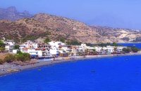 Ierapetra, Lassithi at 20.6km (SE) Myrtos (GR: Μύρτος) is situated 15km to the west of Ierapetra, at the estuaries of the river Sarantapihos, in a valley with olive and orange trees. It is a beautiful village built by the sea, with a beach street lined with taverns and cafe bars. In a short distance from Myrtos on a low hill lies the archaeological site of "Pyrgos" with the ruins of a villa from the post minoan period and a little further at "Fournou Koryfi" lie the ruins of a proto minoan settlement. Myrtos features a small archaeological museum with exhibits mostly from the area, an initiative of a local teacher. Myrtos is a popular tourist destination, with nice small hotels, picturesque taverns and kafeneions, a lovely sandy beach and hospitable people. Image Library
 Gouves, Iraklion at 20.6km (NW) Vorou (or Voritsi) lies at a height of 230 m. above sea-level and counted 62 inhabitants in 1981 and 48 in 2001. It is 25 kms away from Heraklion. To get there, you follow the National Road to Aghios Nikolaos and at kms 17.7 turn right, taking the road Gouves-Skotino- Vorou. Nowadays it is known as Voritsi but this name is not official. The name Vorou, on the other hand, in the district of Pediados is mentioned by Barozzi in 1577. At the beginning of this century there lived a wise man and a healer in the village of Voritsi. His name was Giorgos Konstantoulakis and people flocked from all over to Crete to seek his advice.
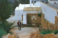 Gouves, Iraklion at 21.1km (NW) At a height of 140m. above sea-level, this village has 142 inhabitants and is 22.5 kms away from Iraklion. According to the villagers, the name comes from the church of Aghios Nikolaos Skotino at the entrance of a cave. It was built at the end of the Venetian period. Today an extra wing has been added, dedicated to Aghios Charalambos. This church of Aghios Nikolaos Skotino presumably functioned as a "Hedge School" (or "Hidden School") under Turkish rule when education had been banned. When the locals said: "We are going to Skotino (which also means "darkness")", they meant they were going to school. Turkish administration refers to this place as Skotino Perasma in 1671. Very close to the village (1.5 km) the cave of Aghia Paraskevi draws crowds of tourists and is well worth a visit.  Iraklion at 21.6km (W) The monastery of Agaráthou (GR: Μονή Αγκαράθου), dedicated to the Virgin, stands at an altitude of 538m, on "Soros Panteli", a rocky hill between the villages of Sgourokefali and Sabas, 23 km from Heraklion. During the period of Venetian rule it was a centre of learning, producing many famous churchmen including the Patriarchs Cyril Lucaris, Meletius Pegas and Sylvester the Cretan. The church was rebuilt in 1894 and flourished once more after the end of the Turkish occupation. Young, educated monks with university degrees have recently settled in the monastery, restoring it to its former glory. 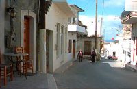 Gouves, Iraklion at 21.8km (NW) Pano Gouves (GR: Πάνω Γούβες) is a village of the district of Pediada in the prefecture of Iraklion at a height of 100 metres above sea-level. It lies twenty kms away from Iraklion, to the right at 17.3 kms on the National Road to Aghios Nikolaos. The village is built on the western flanks of the Ederi hill (322 m.). The name comes from "edera" which means ivy and symbolises affection. The name Gouves, on the other hand, comes from Gouva and means a hollow in the earth. It also means, in Crete, a hole in which during the middle ages, people stored their wheat. The earliest reference we have of the village is that of "Guves" in 1387 documents of the Duke’s archives in Chandax. Later on, in 1577, Fr. Barozzi mentions "Guvos" in the district of Pediados, and then "Guves" in the 1583 Register, with 252 inhabitants. Finally, in 1630, Vassilikata refers to "Vuves’. This is the birthplace of the poet Ioannis Konstantinidis. There are several outstanding churches in the village, among them: Zoodochos Pigis, Aghios Giorgos, Aghios Ioannis and Panayia (dedicated to the birth of Our Lady). 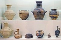 Agios Nikolaos, Lassithi at 22km (E) The Archaeological Museum of Aghios Nikolaos is one of the most important in Crete and has been in operation since 1969. It houses collections of very important archaeological finds from the whole of Eastern Crete, an area extending from Malia as far as Zakros. These are displayed in chronological order from the Neolithic period (5700 - 2800 B.C.) to the end of the Roman times (100 B.C. - 400 A.D.) Its showcases include more than 1350 vases from the 3rd millennium B.C. as well as gold and copper finds (the most ancient found in Crete).
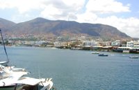
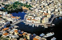 North East Crete, Lassithi at 22.3km (E) Agios Nikólaos (GR: Αγιος Νικόλαος), with 9.500 inhabitants, is the capital of the Lassithi province of Crete. It is built around a picturesque lake at the north-western side of the Mirabello bay, the biggest bay in Crete. Major administrative, cultural and communications center, Agios Nikolaos is one of the most developed tourist areas, not only in Crete but in Greece in general. Thanks to the beautiful coasts, the great sights and the cosmopolitan life, this lively city hosts every year thousands of visitors without losing one bit of its tranquility and traditional hospitality.
Image Library
 Skotino,Gouves, Iraklion at 22.3km (NW) This is one of the three largest caves in the prefecture of Heraklion. It lies at half an hour distance to the north-west from the village of Skotino and is at a height of 225 m. above sea-level. The entrance to the cave is impressive: a large arch, 27 m wide and 10 m high. To the right one can see the ruins of an ancient chapel on which the modern chapel dedicated to Aghia Paraskevi was built. There is a feast held in front of the chapel on July 26th .
 Ierapetra, Lassithi at 23.4km (SE) Between OLEROS and OLERIA there is the village Meseleroi, which took its name from the ancient OLEROS. It is situated at 10 km in the north of Ierapetra at an altitude of 360 m. Ancient Oleros flourished during the classical times, to be conquered by thepowerful Ierapytna. Oleria was a place of worship for Oleria Athena, with its famous statue, venerated by the residents of Oleria and Ierapytna. |
||
|
| ||


';top.fotoWin('/dbsf/pages_pics/15/1522205/aposselemi_gorge01.jpg','');)
)
)
)
C
O
N
T
E
N
T
S
O
N
T
E
N
T
S