interkriti®
YOUR GATEWAY TO CRETE
HOME
CRETE FACTS
NAVIGATE
EXPLORE

Agia Galini
Triopetra
Kissamos
Chryssi Isl.
Agia Marina
Balos
Gavdos isl.
Georgioupolis
SAMARIA
IDA Mtn
Palaiochora
Agia Roumeli
Sfakaki
Bali
Kalamaki
Matala
Lassithi
Plateau Lendas
Tsoutsouros
Vianos
Myrtos
Sfakia
Plakias
Ierapetra
Makrygialos
ZAKROS
Vai
Sitia
Agios Nikolaos
Elounda
MALIA
Hersonissos
Gouves
Chania
Rethymnon
Heraklion
GORTYN
FESTOS
KNOSSOS
|
|
Crete
List Grid Map
Found
187
- Showing :
61 - 80
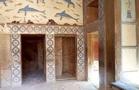 Knossos Palace at 13.6km (S) The Queen's Megaron lies in the Royal Apartments next to the "Hall of the Double Axes". It is a smaller room with a similar layout and rich decoration. Evans thought that it must have belonged to the Queen. Fragments of frescoes with dolphins and dancing ladies were found here. The room is largely restored and copies of the wall paintings have been put up on the walls. At the end of the room, a low partition wall with one column created a small space. It was thought that it was the "Queen's Bathroom" since pieces of a clay "bath" were found there. Pictures: The Queen's Hall 1, 2,3 A corridor joins the "Queens Megaron" with rooms that have been interpreted as places of preparation and washing. 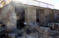 Knossos Palace at 13.6km (S) The magazine to the north of the Grand staircase took its name from the pithoi (large storage jars) that were found here. The jars have relief disk and rope decoration, a characteristic of the beginning of the New palace period (1700-1450 B.C.). A variety of finds show that the place had also been used as a magazine in the Old Palace period (1900-1700 B.C.). Next door is the "Corridor of the Bays", where three small openings were used for storage. Many vases and religious artefacts were found here. The magazines were buried at the end of the New Palace period(1700-1459 B.C.). Image Library
 Knossos Palace at 13.6km (S) Here is the so-called "School Room", an area where, according to Evans, scribes were taught to write on clay tablets. He supposed that they kneaded the clay in the built mortar next to the bench. It is more likely, however that it was a workshop for ceramics or wall-painting. Behind the "School Room" is the "Lapidary's Workshop", where blocks of crude or semi-worked lapis lacedaemoniae (spartan basalt) and stone tools were brought to light. According to Evans, the main workshop lay on the upper floor from which vases and large stone amphora had fallen to the ground floor. 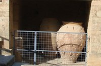 Knossos Palace at 13.6km (S) Here the excavators found a number of very large storage jars (Pithoi) and Evans named the place the "Magazines of the Giant Pithoi". These magazines are one of the older parts of the palace. The pithoi stand out for their size, the number of handles and the richness of their relief decoration with ropes and discs. To the right of the magazines a staircase which has been reconstructed by Evans descends to the east entrance of the Palace. The entrance is a robust construction that gives the impression of a "bastion". From this point it would have been easy to reach an important building of the palatial period, the so-called "Royal Villa" which lies outside the main archaeological site. Image Library
 Knossos Palace at 13.6km (S) The Royal Gaming Board was found here, a kind of board game made of ivory, rock crystal, Egyptian blue, silver and gold, now in Heraklion Museum. To the right of the corridor are the "Royal Pottery Stores", where Kamares pottery of the Old Palace period (1900-1700 B.C.) was uncovered, and to thee left, storage and workshop areas. Image Library
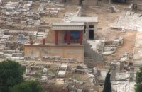 Knossos Palace at 13.6km (S) An open air narrow passage linked the Central Court with the North Entrance. It was paved and had a strong inclination towards the north. Right and left were two raised colonnades known as "Bastions". Arthur Evans reconstructed the "Bastion" on the west side. He also placed a copy of a restored relief fresco of a bull here. The wall painting may have formed part of hunting scene. The passage ends in a large hall with ten square pillars and two columns. The pillars and columns probably supported a large hall on the upper floor. Evans suggested that, due to its position on the seaward side, it was here that the produce of seaborne trade would have been checked when it reached the Palace. It was therefore named the "Customs House". Image Library
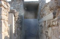
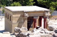 Knossos Palace at 13.6km (S) This room, located beside the north entrance, resembles a cistern. Its floor is lower than the surrounding area and is reached by steps. The "Lustral Basin" was surrounded by columns and was lined with slabs of gypsum giving it a luxurious appearance. In its present form, the area has been completely reconstructed by Evans. Areas with a similar arrangement have been found in other parts of the palace of Knossos, as well as other palaces and important Minoan buildings of the period (1700-1450 B.C.). It is not known how these places were used. However, from their construction it seems that theu would not have been filled with water, nor was there any drainage. Evans thought that they were used in purification ceremonies and therefore called these places "Lustral Basins". Evans also believed that the Palace was a sacred place. That is why, in his opinion, the "Lustral Basin"in question was used to purify visitors going into th Palace via neighbouring North Entrance. Image Library
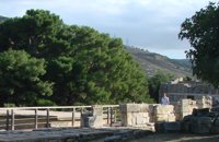
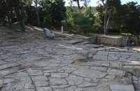 Knossos Palace at 13.6km (S) This area, sited at the north-west edge of the palace, was called the "Theatre" by Evans because its shape reminded him of later theatres. It is a platform and rows of steps that form a right angle. At the base of the stairs is the end of a narrow elevated road that crosses a paved court. Evans believed that the court was used for ceremonies watched by the standing viewers. The elevated paved road continues in the opposite direction. It passes underneath the modern road to Heraklion, connecting the Palace with the Minoan town, which extended to the West and North. Evans named the road the "Royal Road". Along the length of the road are town houses with workshops on the ground floor and residential areas on the upper floor. Image Library
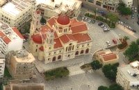 Iraklion Old Town at 13.7km (NE) The Cathedral of St. Minas:The small church of St. Minas did not meet the religious needs of the constantly growing Christian community, so the demand arose for the erection of a new cathedral. The plot for the new church used to be a garden that belonged to a Turk from whom it was bought. The architect was Athanasios Moussis and in 1862 the foundation stone of one of the most magnificent and impressive Greek churches was laid. The outbreak of the Cretan revolution of 1866 demanded the stopping of the building work which will continue in 1883 in order to be completed in 1895, when the inauguration of the exquisite temple took place. The church is of the cruciform type with a dome based on a high spandrel, while internally there are also elements of a three aisle basilica. It has two bell towers, one in the northeastern corner and the other in the southeastern one. The right aisle is dedicated to Apostle Titos and the left one to St. Ten Martyrs of Crete. The inside of the church has gone through many changes with new additions. With plans of the architect Anastasios Orlandos the woodcut icon screen was replaced by another one made of marble, the same happened with the bishop's seat. The religious painting of the church was assigned to St. Kartakis who followed faithfully the principles and the models of the Byzantine icon painting. The hundredth anniversary from the inauguration of the Cathedral Church of St. Minas (1995) was celebrated with every solemnity that is suited in an equal occasion and more specifically to one of the most glorious and imposing Greek churches. Image Library
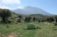 by Richard Ellis at 13.7km (SW) 11th, 12th and 13th June- We had made camp in the yard beside the Aghios Ioannis chapel at Rouvas but, the following morning, it was quite clear that I wasn’t going to go any further on foot until the shin splint had settled down a bit. Minor surgery on the blisters exposed the full extent of those problems and I hung them out to dry in the sun while Triantafyllos went off looking for paths to put on his maps. I think I was lucky not to get infected blisters but Betadine is a great resource which I used extensively.
 by Richard Ellis at 13.7km (SW) 14th June- The walk up from Rouvas is quite straightforward; once you have walked back down the stream from the Rouvas picnic area and turned right (north) up the dry river bed for two hundred yards, you scramble up a short, easy rock section (well sign posted) before the path continues up through open oak woodland (the Rouvas Forest) heading first for the Duo Prinoi chapel, which has a water tap, and then later up and over a ridge, beyond which a small dry water course leads up a steep sided valley to the flat lands of the Nidha plateau. Distance:12 km Time: 4.75 hrs. Mov av 3.7 km/hr Height overnight: 1,360m. 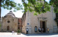 Iraklion at 13.8km (NE) Agia Ekaterini church and Exhibition of Byzantine Art and Ecclesiastical objects. A small sinaitic church of St. Catherine with a Basilica design, houses an exhibition with works of art from the Cretan renaissance. Among the exhibits are some of the most important icons of the Cretan School, ecclesiastical books and manuscripts, vestments, ecclesiastical vessels and relics, wall-paintings, wood-carvings and sculpture. 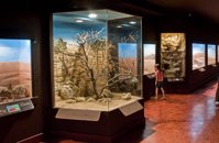 Iraklion, Dermatas Gate at 13.8km (NE) The Natural History Museum of Crete is housed in the renovated former premises of the Heraklion Public Power Corporation, on Dermatas’ Bay. With an area of 3,500 m2, it is the largest exhibition of its kind in the Mediterranean, showcasing the natural environment of Crete and the wider Mediterranean area in an innovative, original way. 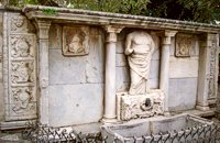 Iraklion at 13.8km (NE) It was made by "capitano" Gianmatteo Bembo between 1552-1554, it dominates in today's Kornarou square, next to a later Turkish philanthropic fountain. It is decorated with coats of arms and other elements of the renaissance and of gothic type, while in the middle a big headless statue stands out of the roman period. The spring is ornated with floral and embossed elements.
Image Library
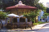 Kornarou square, Iraklion City at 13.8km (NE) It was built in 1776 by Hadji Ibrahim aga. In order to keep it working, he dedicated almost all his property. It is unique in its kind that is still preserved today. It is of a circular type building with a "tholos" and around the walls there are semi-circular windows with rails, in front of each one of them there exist a tap with a stone basin for the water to be collected. Today it is used as a coffeehouse.
Image Library
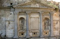 Iraklion at 13.8km (NE) The «General Provisioner» Antonio Priuli made it in 1666 and it is situated today behind the "Bodosakeio" Primary School (in the area of the Venetian Dermata Gate). He decorated it with round and square columns with Corinthian type capitals, while a triangular pediment crowns the whole construction. From both sides of the columns there are niches with their metopes elaborately decorated. In the middle of the fountain there is a Turkish inscription where there is a reference to the name of the Turkish pasha who managed to bring water again in the fountain.
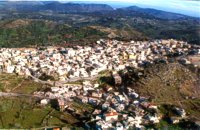 Milopotamos, Rethymno at 14km (W) Anogia is a mountain town with 2500 permanent residents and is 55 km away from Rethymnon and 36 km from Iraklion. The name Anogia, means "high place - Ano Gi", is connected with the location that is built, in altitude of 700 m. Hospitable and pleasant residents have to tell a lot of old stories that have marked the tradition and the culture of the village. Anogia is a well-known village historically for its resident's resistance to the conquerors, Turkish and Germans.
Image Library
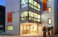 Iraklion at 14km (NE) The Emmetropia Mediterranean Lasik Eye Clinic, a private-sector ophthalmic surgery clinic, offers advanced vision correction in a patient-centered environment. Access to conventional and cutting-edge refractive surgery technologies such us Lasik, Lasek and more, for a wide range of vision problems, enable our physicians to optimize results by meeting each patient´s individual needs. 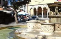 Iraklion Old Town at 14km (NE) The "Morosini's fountain" or "Lions' fountain" that dominates the center of Eleftherios Venizelos square in Iraklion old town, is a landmark both for locals and visitors. A masterpiece of the Venetian era that would be the pride of any city in the world. It was made in 1628 AD, under the supervision of the General Provisioner Francesco Morosini, to satisfy Candia's (Candia was the Venetian name of Crete and its capital - Iraklion - as well) needs for water. For this purpose an aqueduct was constructed to bring the water from the sacred mountain Giouhtas. Image Library
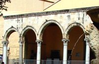 Heraklion old town at 14km (NE) The Basilica of Saint Mark is one of the most important Venetian buildings-monuments in Heraklion. Today it houses the city’s Municipal Art Gallery. The Venetians, wishing to consolidate their dominance over their new colony (Heraklion) and to express their gratitude and love for their mother country, built a church in the city’s centre dedicated to Saint Mark, patron saint of Venice. The Basilica managed to survive various earthquakes which afflicted Heraklion over the centuries with only minor repairs. During the Turkish rule it was converted into a mosque, the Defterdar Mosque, named after Defterdar Ahmet Pasha, the head of the financial department. The Ottomans demolished the bell-tower of the basilica and raised a minaret in its place, which in its turn was taken down by the residents of Heraklion after the liberation of the island in their attempt to erase the unpleasant reminders and symbols of the Turkish occupation.
Image Library
|
||
|
| ||


;)
;)
;)
';top.fotoWin('/dbsf/pages_pics/15/1512321/giant_pithoi01.jpg');)
C
O
N
T
E
N
T
S
O
N
T
E
N
T
S